
Geographic Region: USA-CALIFORNIA
Feature: DEATH VALLEY, PART. FR.
|
Geographic Region: USA-CALIFORNIA Feature: DEATH VALLEY, PART. FR. |
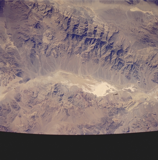 |
| STS058-083-028 Death Valley, California, U.S.A. October 1993 Death Valley, the lowest point in the United States at 282 feet (86 meters) below sea level, is the white area at the northern end of this graben. In contrast, the brown Panamint Mountains that border Death Valley on the west have a series of ridge lines that exceed 7000 feet (2135 meters) and a maximum peak of 11 048 feet (3365 meters). A series of alluvial fans flanks the Panamints' eastern side, and an elongated, tan, dry lakebed lies just west of the mountain range. |
| Images: | All Available Images Low-Resolution 310k |
|
| Mission: | STS058 |
|
| Roll - Frame: | 83 - 28 |
|
| Geographical Name: | USA-CALIFORNIA |
|
| Features: | DEATH VALLEY, PART. FR. |
|
| Center Lat x Lon: | 36.0N x 117W |
|
| Film Exposure: | N | N=Normal exposure, U=Under exposed, O=Over exposed, F=out of Focus |
| Percentage of Cloud Cover-CLDP: | 0 |
|
| Camera:: | HB |
|
| Camera Tilt: | 38 | LO=Low Oblique, HO=High Oblique, NV=Near Vertical |
| Camera Focal Length: | 250 |
|
| Nadir to Photo Center Direction: | W | The direction from the nadir to the center point, N=North, S=South, E=East, W=West |
| Stereo?: | N | Y=Yes there is an adjacent picture of the same area, N=No there isn't |
| Orbit Number: | 37 |
|
| Date: | 19931020 | YYYYMMDD |
| Time: | 211745 | GMT HHMMSS |
| Nadir Lat: | 35.3N |
Latitude of suborbital point of spacecraft |
| Nadir Lon: | 115.1W |
Longitude of suborbital point of spacecraft |
| Sun Azimuth: | 216 | Clockwise angle in degrees from north to the sun measured at the nadir point |
| Space Craft Altitude: | 156 | nautical miles |
| Sun Elevation: | 37 | Angle in degrees between the horizon and the sun, measured at the nadir point |
| Land Views: | VALLEY, MOUNTAIN, FAULT |
|
| Water Views: | PLAYA |
|
| Atmosphere Views: | |
|
| Man Made Views: | |
|
| City Views: | |
|
Photo is not associated with any sequences | ||
| NASA Home Page |
JSC Home Page |
JSC Digital Image Collection |
Earth Science & Remote Sensing |
|
This service is provided by the International Space Station program and the JSC Earth Science & Remote Sensing Unit, ARES Division, Exploration Integration Science Directorate.

|