
Geographic Region: USA-CALIFORNIA
Feature: SAN FRANCISCO, PART. FR.
|
Geographic Region: USA-CALIFORNIA Feature: SAN FRANCISCO, PART. FR. |
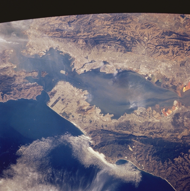 |
| STS058-083-023 San Francisco Bay, California, U.S.A. October 1993 Several natural features are captured in this synoptic photograph of the San Francisco Bay Area--the Montara Mountains and Cahill Ridge that abut the San Andreas Fault, upon which lie San Andreas Lake and elongated Crystal Springs Reservoir; several ridges east of Oakland and Hayward; and Alcatraz Island and Treasure Island, north and north-northeast, respectively, of downtown San Francisco. Discernible are three major bridges (San Mateo, San Francisco-Oakland Bay, and Golden Gate) that connect the cities surrounding San Francisco Bay; the intersecting runways of San Francisco International Airport along the west side of the bay; and dark, elongated Golden Gate Park south of the Golden Gate Bridge. Lining the southern end of the bay are multicolored salt ponds where salt is extracted from sea water. Wispy clouds obscure some of the details in the Richmond area to the northeast. |
| Images: | All Available Images Low-Resolution 345k |
|
| Mission: | STS058 |
|
| Roll - Frame: | 83 - 23 |
|
| Geographical Name: | USA-CALIFORNIA |
|
| Features: | SAN FRANCISCO, PART. FR. |
|
| Center Lat x Lon: | 37.5N x 122.5W |
|
| Film Exposure: | N | N=Normal exposure, U=Under exposed, O=Over exposed, F=out of Focus |
| Percentage of Cloud Cover-CLDP: | 10 |
|
| Camera:: | HB |
|
| Camera Tilt: | 20 | LO=Low Oblique, HO=High Oblique, NV=Near Vertical |
| Camera Focal Length: | 250 |
|
| Nadir to Photo Center Direction: | E | The direction from the nadir to the center point, N=North, S=South, E=East, W=West |
| Stereo?: | N | Y=Yes there is an adjacent picture of the same area, N=No there isn't |
| Orbit Number: | 37 |
|
| Date: | 19931020 | YYYYMMDD |
| Time: | 211555 | GMT HHMMSS |
| Nadir Lat: | 37.2N |
Latitude of suborbital point of spacecraft |
| Nadir Lon: | 123.4W |
Longitude of suborbital point of spacecraft |
| Sun Azimuth: | 205 | Clockwise angle in degrees from north to the sun measured at the nadir point |
| Space Craft Altitude: | 156 | nautical miles |
| Sun Elevation: | 39 | Angle in degrees between the horizon and the sun, measured at the nadir point |
| Land Views: | MOUNTAIN, FAULT, COAST |
|
| Water Views: | BAY, SEDIMENT |
|
| Atmosphere Views: | |
|
| Man Made Views: | URBAN AREA |
|
| City Views: | SAN FRANCISCO, OAKLAND |
|
Photo is not associated with any sequences | ||
| NASA Home Page |
JSC Home Page |
JSC Digital Image Collection |
Earth Science & Remote Sensing |
|
This service is provided by the International Space Station program and the JSC Earth Science & Remote Sensing Unit, ARES Division, Exploration Integration Science Directorate.

|