Geographic Region: CHINA
Feature: PAN-TIBETAN PLAT,LAKES
|
Geographic Region: CHINA Feature: PAN-TIBETAN PLAT,LAKES |
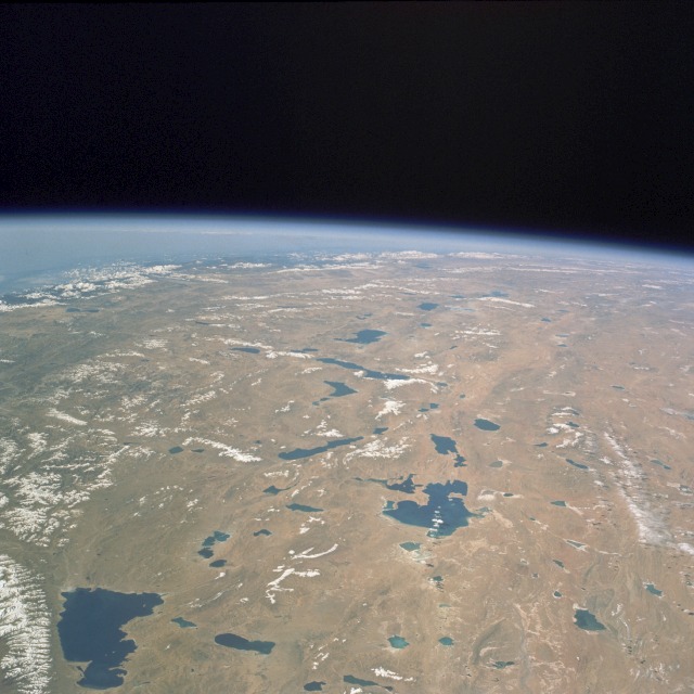 |
| STS058-074-010 Tibetan Plateau, China October 1993 The southeast portion of the high Tibetan Plateau, called the Northern Plain by the Chinese, is seen in this southwest-looking, high-oblique photograph. The plateau, with elevations between 13 000 and 16 000 feet (4000 and 4900 meters), stretches for 800 miles (1300 kilometers) and is surrounded by massive mountain ranges. Many great rivers originate in the Tibetan Plateau--Indus, Brahmaputra, Sutlej, Salween, Mekong, Yangtze, and Yellow. The plateau has no river system; however, it has numerous brackish lakes, some of which are visible in this photograph. Saline Nam Co Lake (southeast corner of photograph), the largest lake in Tibet, covers 950 square miles (2461 square kilometers) and sits at an altitude of 15 180 feet (4630 meters). Although the plateau is a barren wasteland with virtually no trees or bushes, the light precipitation--averaging between 5 and 15 inches (125 and 380 centimeters) annually--does produce a summer grass crop that is vital for grazing. Some grain crops, primarily barley and buckwheat, are grown in the valleys. The Tibetan Plateau has large deposits of gold, copper, and radioactive ores, but mining is prohibited for religious reasons. |
| Images: | All Available Images Low-Resolution 104k |
|
| Mission: | STS058 |
|
| Roll - Frame: | 74 - 10 |
|
| Geographical Name: | CHINA |
|
| Features: | PAN-TIBETAN PLAT,LAKES |
|
| Center Lat x Lon: | 31.5N x 88.0E |
|
| Film Exposure: | N | N=Normal exposure, U=Under exposed, O=Over exposed, F=out of Focus |
| Percentage of Cloud Cover-CLDP: | 0 |
|
| Camera:: | HB |
|
| Camera Tilt: | HO | LO=Low Oblique, HO=High Oblique, NV=Near Vertical |
| Camera Focal Length: | 100 |
|
| Nadir to Photo Center Direction: | W | The direction from the nadir to the center point, N=North, S=South, E=East, W=West |
| Stereo?: | N | Y=Yes there is an adjacent picture of the same area, N=No there isn't |
| Orbit Number: | 25 |
|
| Date: | 19931020 | YYYYMMDD |
| Time: | 030245 | GMT HHMMSS |
| Nadir Lat: | 32.0N |
Latitude of suborbital point of spacecraft |
| Nadir Lon: | 95.0E |
Longitude of suborbital point of spacecraft |
| Sun Azimuth: | 135 | Clockwise angle in degrees from north to the sun measured at the nadir point |
| Space Craft Altitude: | 155 | nautical miles |
| Sun Elevation: | 36 | Angle in degrees between the horizon and the sun, measured at the nadir point |
| Land Views: | PLATEAU, MOUNTAIN, DESERT |
|
| Water Views: | LAKE |
|
| Atmosphere Views: | |
|
| Man Made Views: | |
|
| City Views: | |
|
Photo is not associated with any sequences | ||
| NASA Home Page |
JSC Home Page |
JSC Digital Image Collection |
Earth Science & Remote Sensing |
|
This service is provided by the International Space Station program and the JSC Earth Science & Remote Sensing Unit, ARES Division, Exploration Integration Science Directorate.

|