
Geographic Region: PARAGUAY
Feature: CONCEPION, PARAGUAY R.
|
Geographic Region: PARAGUAY Feature: CONCEPION, PARAGUAY R. |
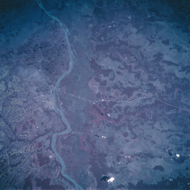 |
| STS058-112-028 Paraguay River, Conception Area, Paraguay October 1993 The Paraguay River separates the landlocked country of Paraguay into sharply contrasting regions. East of the river (left) the topography consists of low plateaus, rolling hills, grasslands, and forests. West of the Paraguay River the landscape changes to a relatively flat alluvial plain with much of the area covered by permanent swamps. The region is known as the Paraguayan Chaco, which consists of palm forests and extensive marshes. The Paraguay River is subject to annual flooding and frequent shifts of its main channel. Notice in this color infrared image that the broad extent of the Paraguay River floodplain is represented by a pinkish strip (top center to bottom center) along the west bank of the river. The darker, clustered areas show the location of dense stands of vegetation, mainly woodlands. The thin, light-colored, lines (especially the east-west line running through the middle of the picture) are highways. The river city of Conception (light-colored area along the east side of the river) can be identified near the left (middle) margin of the image. The small, blotchy-looking terrain west of Conception is the result of intensive agricultural operations on the more elevated land. |
| Images: | All Available Images Low-Resolution 302k |
|
| Mission: | STS058 |
|
| Roll - Frame: | 112 - 28 |
|
| Geographical Name: | PARAGUAY |
|
| Features: | CONCEPION, PARAGUAY R. |
|
| Center Lat x Lon: | 23.5S x 57.5W |
|
| Film Exposure: | N | N=Normal exposure, U=Under exposed, O=Over exposed, F=out of Focus |
| Percentage of Cloud Cover-CLDP: | 0 |
|
| Camera:: | HB |
|
| Camera Tilt: | LO | LO=Low Oblique, HO=High Oblique, NV=Near Vertical |
| Camera Focal Length: | 250 |
|
| Nadir to Photo Center Direction: | The direction from the nadir to the center point, N=North, S=South, E=East, W=West |
|
| Stereo?: | Y | Y=Yes there is an adjacent picture of the same area, N=No there isn't |
| Orbit Number: | |
|
| Date: | 1993____ | YYYYMMDD |
| Time: | GMT HHMMSS |
|
| Nadir Lat: | N |
Latitude of suborbital point of spacecraft |
| Nadir Lon: | E |
Longitude of suborbital point of spacecraft |
| Sun Azimuth: | Clockwise angle in degrees from north to the sun measured at the nadir point |
|
| Space Craft Altitude: | nautical miles |
|
| Sun Elevation: | Angle in degrees between the horizon and the sun, measured at the nadir point |
|
| Land Views: | PLAIN, HILL |
|
| Water Views: | RIVER |
|
| Atmosphere Views: | |
|
| Man Made Views: | URBAN AREA |
|
| City Views: | |
|
Photo is not associated with any sequences | ||
| NASA Home Page |
JSC Home Page |
JSC Digital Image Collection |
Earth Science & Remote Sensing |
|
This service is provided by the International Space Station program and the JSC Earth Science & Remote Sensing Unit, ARES Division, Exploration Integration Science Directorate.

|