Geographic Region: JAPAN
Feature: SAKURA-JIMA VOLCANO
|
Geographic Region: JAPAN Feature: SAKURA-JIMA VOLCANO |
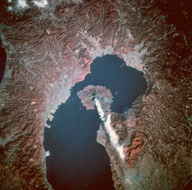 |
| STS058-111-84 Sakura-jima Volcano, Kyushu, Japan October 1993 Sakura-jima, a very active stratovolcano rising 3665 feet (1117 meters) above sea level, is located on a small peninsula near the northern end of Kagoshima Bay along the southern coast of Kyushu Island. This closeup, near-vertical, infrared photograph shows two craters---one with an ash plume along the volcano's southern flank and another farther north. The absence of red coloring, indicating little or no vegetation, confirms that the most recent lava flows occurred on the eastern flank of the volcano. The volcano's Minami-dake crater produces an eruption with a minimal ash plume almost daily. The characteristic radial drainage pattern for most stratovolcanoes is observed for Sakura-jima. The infrared film helps accentuate the blue-gray urban areas and the pink agricultural and forested areas. Visible are the larger port city of Kagoshima west of Sakura-jima Volcano, the two smaller cities of Kajiki and Kokubu, and an airport with one runway along the northern end of Kagoshima Bay. |
| Images: | All Available Images Low-Resolution 171k |
|
| Mission: | STS058 |
|
| Roll - Frame: | 111 - 84 |
|
| Geographical Name: | JAPAN |
|
| Features: | SAKURA-JIMA VOLCANO |
|
| Center Lat x Lon: | 31.5N x 130.5E |
|
| Film Exposure: | N | N=Normal exposure, U=Under exposed, O=Over exposed, F=out of Focus |
| Percentage of Cloud Cover-CLDP: | 0 |
|
| Camera:: | HB |
|
| Camera Tilt: | 14 | LO=Low Oblique, HO=High Oblique, NV=Near Vertical |
| Camera Focal Length: | 250 |
|
| Nadir to Photo Center Direction: | N | The direction from the nadir to the center point, N=North, S=South, E=East, W=West |
| Stereo?: | Y | Y=Yes there is an adjacent picture of the same area, N=No there isn't |
| Orbit Number: | 39 |
|
| Date: | 19931021 | YYYYMMDD |
| Time: | 000304 | GMT HHMMSS |
| Nadir Lat: | 30.9N |
Latitude of suborbital point of spacecraft |
| Nadir Lon: | 130.3E |
Longitude of suborbital point of spacecraft |
| Sun Azimuth: | 126 | Clockwise angle in degrees from north to the sun measured at the nadir point |
| Space Craft Altitude: | 152 | nautical miles |
| Sun Elevation: | 30 | Angle in degrees between the horizon and the sun, measured at the nadir point |
| Land Views: | MOUNTAIN, VOLCANO, COAST, ISLAND |
|
| Water Views: | BAY |
|
| Atmosphere Views: | SMOKE, PLUME |
|
| Man Made Views: | URBAN AREA, AIRPORT, AGRICULTURE |
|
| City Views: | |
|
Photo is not associated with any sequences | ||
| NASA Home Page |
JSC Home Page |
JSC Digital Image Collection |
Earth Science & Remote Sensing |
|
This service is provided by the International Space Station program and the JSC Earth Science & Remote Sensing Unit, ARES Division, Exploration Integration Science Directorate.

|