
Geographic Region: ITALY
Feature: POINT STILO
|
Geographic Region: ITALY Feature: POINT STILO |
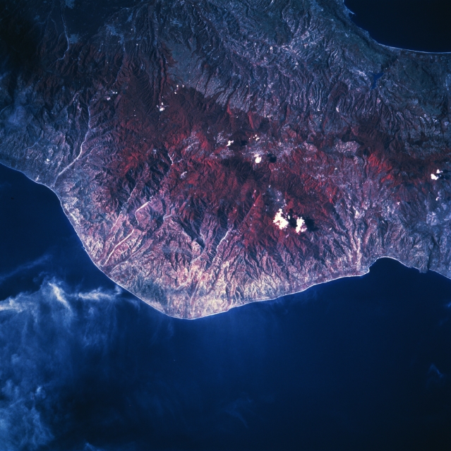 |
| STS058-109-039 Point Stilo, Italy October 1993 The color infrared image (green vegetation is portrayed as shades of red) accentuates the heavily forested mountainous terrain (center of image), known as the Serre, in the Calabria region of southern Italy. Forest species include firs, beeches, and chestnut trees. Mt. Pecorara, highest peak in the Serre Mountains (4668 feet-1422 meters), is located near the center of the picture. Many scenic gorges have been carved out of the mountains by swift-flowing, short rivers that drain to the southeast into the Ionian Sea (bottom). Part of the narrowest point (22 miles-35 km) in Italy, the isthmus of Marcellinara, can be seen along the north (right) edge of the image. A small section of the Tyrrhenian Sea is visible as a dark feature in the top right corner (upper right). Because of the ruggedness of the terrain this region is sparsely populated. Some clouds are visible just south of Point Stilo (lower left quadrant of the image). |
| Images: | All Available Images Low-Resolution 322k |
|
| Mission: | STS058 |
|
| Roll - Frame: | 109 - 39 |
|
| Geographical Name: | ITALY |
|
| Features: | POINT STILO |
|
| Center Lat x Lon: | 38.5N x 16.5E |
|
| Film Exposure: | N | N=Normal exposure, U=Under exposed, O=Over exposed, F=out of Focus |
| Percentage of Cloud Cover-CLDP: | 5 |
|
| Camera:: | HB |
|
| Camera Tilt: | 13 | LO=Low Oblique, HO=High Oblique, NV=Near Vertical |
| Camera Focal Length: | 250 |
|
| Nadir to Photo Center Direction: | SW | The direction from the nadir to the center point, N=North, S=South, E=East, W=West |
| Stereo?: | N | Y=Yes there is an adjacent picture of the same area, N=No there isn't |
| Orbit Number: | 46 |
|
| Date: | 19931021 | YYYYMMDD |
| Time: | 104350 | GMT HHMMSS |
| Nadir Lat: | 38.9N |
Latitude of suborbital point of spacecraft |
| Nadir Lon: | 16.9E |
Longitude of suborbital point of spacecraft |
| Sun Azimuth: | 182 | Clockwise angle in degrees from north to the sun measured at the nadir point |
| Space Craft Altitude: | 151 | nautical miles |
| Sun Elevation: | 40 | Angle in degrees between the horizon and the sun, measured at the nadir point |
| Land Views: | MOUNTAIN |
|
| Water Views: | SEA |
|
| Atmosphere Views: | |
|
| Man Made Views: | |
|
| City Views: | |
|
Photo is not associated with any sequences | ||
| NASA Home Page |
JSC Home Page |
JSC Digital Image Collection |
Earth Science & Remote Sensing |
|
This service is provided by the International Space Station program and the JSC Earth Science & Remote Sensing Unit, ARES Division, Exploration Integration Science Directorate.

|