
Geographic Region: USA-TEXAS
Feature: SAN ANTONIO, RIV., RES.
|
Geographic Region: USA-TEXAS Feature: SAN ANTONIO, RIV., RES. |
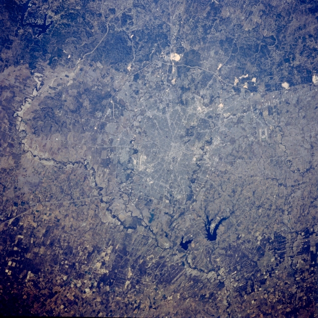 |
| STS058-101-053 San Antonio, Texas, U.S.A. October 1993 Downtown San Antonio is the point of convergence of a major highway system (center of photograph). East and west of the central business district are curving north-south-oriented Salado Creek and Leon Creek, respectively, both of which flow into the Medina River south of the city. The meandering Medina River and its floodplain are prominent features as they loop around the west and south sides of the city. Visible are the runways of Kelly Air Force Base (southwest) and Randolph Air Force Base (northeast) and Calaveras Lake and smaller Braunig Lake to the southeast. An edge of the deeply dissected Edwards Plateau, known locally as the Texas Hill Country, is visible north of the city. Highly reflective limestone quarries appear within the uplifted sedimentary rocks along the Balcones fault system. The mined limestone is used to make cement and road gravel. This sharp cloud-free photograph of San Antonio, Texas illustrates the classic pattern of western cities. The Hispanic heart of the city, an intertwining of streets along the San Antonio River and around the Alamo, surrounded by a late 19th century Anglo grid of small businesses and suburban homes. Transportation routes radiate to mid and late 20th century ring corridors separating the urban/suburban region from the surrounding agricultural countryside. Limestone quarries are conspicuous along the edge of the Balcones Escarpment, at the foot of which San Antonio was founded. Randolph Air Force Base is outside the city to the northeast, Fort Sam Houston is contained within the northeast quadrant of the city, Brooks Air Force Base lies at the southeastern corner, and Lackland and Kelly Air Force Bases are within the suburban fringe to the southwest. San Antonio International Airport can be seen at the foot of the escarpment in the northern part of the city. |
| Images: | All Available Images Low-Resolution 401k |
|
| Mission: | STS058 |
|
| Roll - Frame: | 101 - 53 |
|
| Geographical Name: | USA-TEXAS |
|
| Features: | SAN ANTONIO, RIV., RES. |
|
| Center Lat x Lon: | 29.5N x 98.5W |
|
| Film Exposure: | N | N=Normal exposure, U=Under exposed, O=Over exposed, F=out of Focus |
| Percentage of Cloud Cover-CLDP: | 0 |
|
| Camera:: | HB |
|
| Camera Tilt: | 35 | LO=Low Oblique, HO=High Oblique, NV=Near Vertical |
| Camera Focal Length: | 250 |
|
| Nadir to Photo Center Direction: | E | The direction from the nadir to the center point, N=North, S=South, E=East, W=West |
| Stereo?: | Y | Y=Yes there is an adjacent picture of the same area, N=No there isn't |
| Orbit Number: | 84 |
|
| Date: | 19931023 | YYYYMMDD |
| Time: | 195423 | GMT HHMMSS |
| Nadir Lat: | 29.5N |
Latitude of suborbital point of spacecraft |
| Nadir Lon: | 100.3W |
Longitude of suborbital point of spacecraft |
| Sun Azimuth: | 211 | Clockwise angle in degrees from north to the sun measured at the nadir point |
| Space Craft Altitude: | 152 | nautical miles |
| Sun Elevation: | 44 | Angle in degrees between the horizon and the sun, measured at the nadir point |
| Land Views: | PLAIN, HILL, ESCARPMENT |
|
| Water Views: | RIVER, RESERVOIR |
|
| Atmosphere Views: | |
|
| Man Made Views: | HIGHWAY, URBAN AREA, AIRPORT, MINING |
|
| City Views: | |
|
Photo is not associated with any sequences | ||
| NASA Home Page |
JSC Home Page |
JSC Digital Image Collection |
Earth Science & Remote Sensing |
|
This service is provided by the International Space Station program and the JSC Earth Science & Remote Sensing Unit, ARES Division, Exploration Integration Science Directorate.

|