
Geographic Region: AUSTRALIA-WA
Feature: KING SOUND, COAST
|
Geographic Region: AUSTRALIA-WA Feature: KING SOUND, COAST |
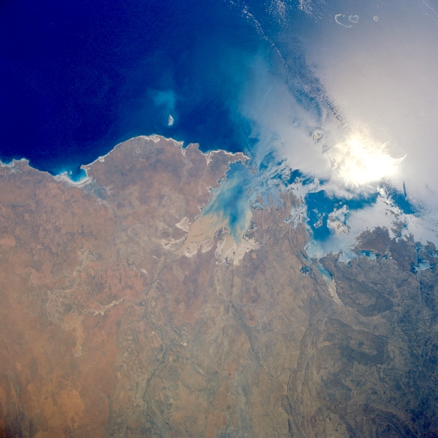 |
| STS057-90-9 King Sound, Western Australia, Australia June 1993 The two larger bays shown in this section of the north coast of Western Australia are King Sound and Collier Bay. Buccaneer Archipelago extends northwestward from the peninsula separating the two bodies of water. In southern King Sound is a brownish sediment plume, where the Fitzroy River empties into the bay. Collier Bay is northeast of King Sound and south of the highly reflective sunglint patch. The small inlet near left center is Roebuck Bay, with the large peninsula of Dampier Land between it and King Sound. STS-57 Earth observation taken aboard Endeavour, Orbiter Vehicle (OV) 105, is of King Sound in northwest Australia. Roebuck Bay with the city of Broom on its northern shore is south of King Sound. Sediment in the sound is deposited by the Fitzroy River, which is the major body draining the Kimberley Plateau about 200 miles to the west. The extent of the tidal flats around the Sound is indicated by the large white areas covered with a salty residue. According to NASA scientists studying the STS-57 Earth photos, northwest wind gusts are ruffling areas of the water's surface at the mouth of King Sound and in neighboring Collier Bay. Therefore the water is less reflective and dark. The higher reflectance on the brightest areas is caused by biological oils floating on the surface and reducing the capillary wave action. The scientists point out that the oils take the forms of the currents and eddies in the picture. These eddies indicate that the water offshore is moving at a different speed |
| Images: | All Available Images Low-Resolution 301k |
|
| Mission: | STS057 |
|
| Roll - Frame: | 90 - 9 |
|
| Geographical Name: | AUSTRALIA-WA |
|
| Features: | KING SOUND, COAST |
|
| Center Lat x Lon: | 16.5S x 123.0E |
|
| Film Exposure: | N | N=Normal exposure, U=Under exposed, O=Over exposed, F=out of Focus |
| Percentage of Cloud Cover-CLDP: | 0 |
|
| Camera:: | HB |
|
| Camera Tilt: | 15 | LO=Low Oblique, HO=High Oblique, NV=Near Vertical |
| Camera Focal Length: | 50 |
|
| Nadir to Photo Center Direction: | N | The direction from the nadir to the center point, N=North, S=South, E=East, W=West |
| Stereo?: | Y | Y=Yes there is an adjacent picture of the same area, N=No there isn't |
| Orbit Number: | 134 |
|
| Date: | 19930630 | YYYYMMDD |
| Time: | 042832 | GMT HHMMSS |
| Nadir Lat: | 17.5S |
Latitude of suborbital point of spacecraft |
| Nadir Lon: | 123.5E |
Longitude of suborbital point of spacecraft |
| Sun Azimuth: | 346 | Clockwise angle in degrees from north to the sun measured at the nadir point |
| Space Craft Altitude: | 247 | nautical miles |
| Sun Elevation: | 48 | Angle in degrees between the horizon and the sun, measured at the nadir point |
| Land Views: | COAST |
|
| Water Views: | BAY, SEDIMENT |
|
| Atmosphere Views: | |
|
| Man Made Views: | |
|
| City Views: | |
|
Photo is not associated with any sequences | ||
| NASA Home Page |
JSC Home Page |
JSC Digital Image Collection |
Earth Science & Remote Sensing |
|
This service is provided by the International Space Station program and the JSC Earth Science & Remote Sensing Unit, ARES Division, Exploration Integration Science Directorate.

|