
Geographic Region: AUSTRALIA-WA
Feature: KING SOUND,COAST,INLAND
|
Geographic Region: AUSTRALIA-WA Feature: KING SOUND,COAST,INLAND |
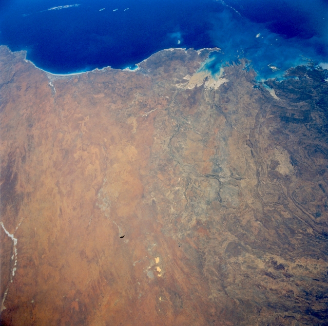 |
| STS057-090-012 Great Sandy Desert, Western Australia, Australia June 1993 A large section of the Great Sandy Desert is covered in this view of northern Western Australia. The Great Sandy Desert, one of the major deserts of Australia, consists of relatively flat to rolling terrain with numerous dunefields, sandy grasslands, and sand ridges. The transition zone between the Great Sandy Desert and the low mountainous region to the northeast,, known as the Kimberley, is the zone of subtly different color and texture that extends from the coast to roughly the center of the frame. The Indian Ocean spans the upper field of view, from beyond 80 Mile Beach (left), northeastward to Collier Bay (right). King Sound is the sediment-laden bay (middle). Aboriginal reserves occupy the peninsulas flanking King Sound. Beagle Bay is a small inlet on the northwest coast of the large peninsula, known as Dampier Land, west of King Sound. The linear, light-colored feature along the left bottom of the picture is the southeastern end of the Percival Lakes. Ephemeral Lakes Betty and McLernon are the bright features at bottom center. |
| Images: | All Available Images Low-Resolution 326k |
|
| Mission: | STS057 |
|
| Roll - Frame: | 90 - 12 |
|
| Geographical Name: | AUSTRALIA-WA |
|
| Features: | KING SOUND,COAST,INLAND |
|
| Center Lat x Lon: | 18.5S x 123.5E |
|
| Film Exposure: | N | N=Normal exposure, U=Under exposed, O=Over exposed, F=out of Focus |
| Percentage of Cloud Cover-CLDP: | 0 |
|
| Camera:: | HB |
|
| Camera Tilt: | 38 | LO=Low Oblique, HO=High Oblique, NV=Near Vertical |
| Camera Focal Length: | 50 |
|
| Nadir to Photo Center Direction: | W | The direction from the nadir to the center point, N=North, S=South, E=East, W=West |
| Stereo?: | N | Y=Yes there is an adjacent picture of the same area, N=No there isn't |
| Orbit Number: | 134 |
|
| Date: | 19930630 | YYYYMMDD |
| Time: | 042926 | GMT HHMMSS |
| Nadir Lat: | 18.8S |
Latitude of suborbital point of spacecraft |
| Nadir Lon: | 126.7E |
Longitude of suborbital point of spacecraft |
| Sun Azimuth: | 342 | Clockwise angle in degrees from north to the sun measured at the nadir point |
| Space Craft Altitude: | 249 | nautical miles |
| Sun Elevation: | 46 | Angle in degrees between the horizon and the sun, measured at the nadir point |
| Land Views: | DESERT |
|
| Water Views: | BAY, PLAYA |
|
| Atmosphere Views: | |
|
| Man Made Views: | |
|
| City Views: | |
|
Photo is not associated with any sequences | ||
| NASA Home Page |
JSC Home Page |
JSC Digital Image Collection |
Earth Science & Remote Sensing |
|
This service is provided by the International Space Station program and the JSC Earth Science & Remote Sensing Unit, ARES Division, Exploration Integration Science Directorate.

|