 Photo #: STS057-73-75 Date: Jun. 1993
Geographic Region: MEDITERRANEAN SEA
Feature: PAN-NILE DELTA, TURKEY

 Photo #: STS057-73-75 Date: Jun. 1993 Photo #: STS057-73-75 Date: Jun. 1993Geographic Region: MEDITERRANEAN SEA Feature: PAN-NILE DELTA, TURKEY |
 |
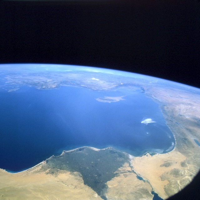
| STS057-73-75 Eastern Mediterranean Sea Area June 1993 The lands of the eastern Mediterranean Sea are featured in this spectacular, high-oblique, north-looking photograph. The island of Cyprus, near the center of the photograph, is partially obscured by dust; north of Cyprus is Turkey. The whitish object north of Cyprus and just north of the Turkish coast is Tuz Lake, a shallow, salt lake located in the middle of the Konya Plain of central Turkey. North-northeast of Cyprus is the Gulf of Alexandria, surrounded by the darker-colored Taurus Mountains. The coasts of Syria, Lebanon, and Israel are visible east and southeast of Cyprus. The dark-green Nile River Delta, bordered by the yellowish-orange sands of the Egyptian desert, can be seen along the coast west of Israel. The line just east of the delta traversing southward from the blue Mediterranean Sea is the Suez Canal. East of the canal, the border is a straight line between the brown vegetated lands of Israel and the brighter yellowish sands of the northern desert of the Sinai Peninsula in Egypt. Slightly east-northeast of the border are the pale blue waters of the Dead Sea. Cairo, Egypt, is the darkish-gray smudge near the apex of the Nile River Delta. STS-57 Earth observation of the Eastern Mediterranean. From a high vantage point over the Nile River, this north-looking view shows the eastern Mediterranean and the entire landmass of Asia Minor, with the Black Sea dimly visible at the horizon. Many of the Greek islands can be seen in the Aegean Sea (top left), off the coast of Asia Minor. Cyprus is visible under atmospheric dust in the northeastern corner of the Mediterranean. The dust cloud covers the east end of the Mediterranean, its western edge demarcated by a line that cuts the center of the Nile Delta. This dust cloud originated far to the west, in Algeria, and moved northeast. A gyre of clouds in the southeast corner of the Mediterranean indicates a complementary counterclockwise (cyclonic) circulation of air. The Euphrates River appears as a thin green line (upper right) in the yellow Syrian desert just south of the mountains of Turkey. The Dead Sea (lower right) lies in a rift valley which extends north into Turkey and sout |
| Images: | All Available Images Low-Resolution 88k |
|
| Mission: | STS057 |
|
| Roll - Frame: | 73 - 75 |
|
| Geographical Name: | MEDITERRANEAN SEA |
|
| Features: | PAN-NILE DELTA, TURKEY |
|
| Center Lat x Lon: | 33.0N x 32.0E |
|
| Film Exposure: | N | N=Normal exposure, U=Under exposed, O=Over exposed, F=out of Focus |
| Percentage of Cloud Cover-CLDP: | 5 |
|
| Camera:: | HB |
|
| Camera Tilt: | HO | LO=Low Oblique, HO=High Oblique, NV=Near Vertical |
| Camera Focal Length: | 100 |
|
| Nadir to Photo Center Direction: | NE | The direction from the nadir to the center point, N=North, S=South, E=East, W=West |
| Stereo?: | N | Y=Yes there is an adjacent picture of the same area, N=No there isn't |
| Orbit Number: | 28 |
|
| Date: | 19930623 | YYYYMMDD |
| Time: | 071351 | GMT HHMMSS |
| Nadir Lat: | 27.4N |
Latitude of suborbital point of spacecraft |
| Nadir Lon: | 28.9E |
Longitude of suborbital point of spacecraft |
| Sun Azimuth: | 86 | Clockwise angle in degrees from north to the sun measured at the nadir point |
| Space Craft Altitude: | 225 | nautical miles |
| Sun Elevation: | 51 | Angle in degrees between the horizon and the sun, measured at the nadir point |
| Land Views: | ISLAND, COAST, RIFT, DESERT |
|
| Water Views: | SEA, RIVER, DELTA, LAKE |
|
| Atmosphere Views: | DUST |
|
| Man Made Views: | AGRICULTURE, URBAN AREA |
|
| City Views: | |
|
Photo is not associated with any sequences | ||
| NASA Home Page |
JSC Home Page |
JSC Digital Image Collection |
Earth Science & Remote Sensing |
|
|