
Geographic Region: PERU
Feature: JUNIN LAKE
|
Geographic Region: PERU Feature: JUNIN LAKE |
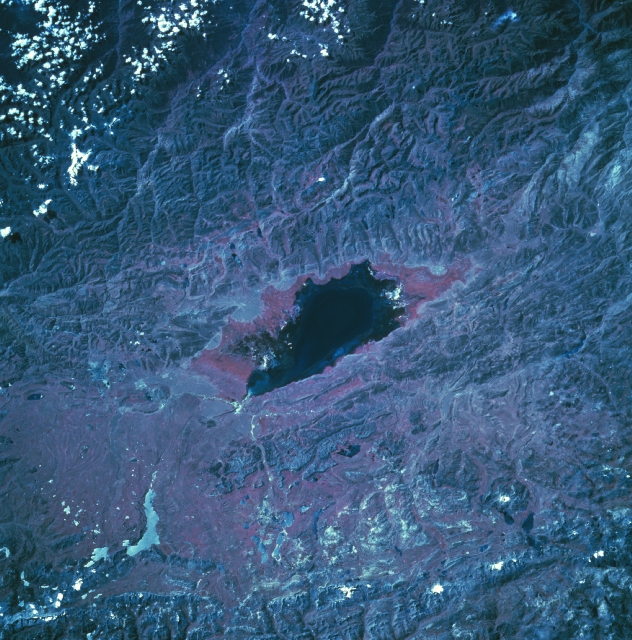 |
| STS057-106-056 Lake Junin, Andes Mountains, Peru June 1993 The dark feature in the center of the color infrared image is Lake Junin. Located at approximately 13393 feet (4082 meters) above sea level, Lake Junin is about 90 miles (145 kilometers) northeast of Lima in the Andes Mountains. Numerous erosional stream channels and deep canyons are visible at the top (northeast) of the image. The rivers drain eastward and eventually flow into the Amazon Basin of eastern Peru. Notice that there is a redder border that encircles three-quarters of the lake (except the southwest coast). This is an indication that healthy green vegetation (green, chlorophyll-bearing vegetation is portrayed as reddish hues in color infrared images) can be mapped around most of the periphery of the lake. The lake measures roughly 25 miles (40 kilometers) in length and approximately 9 miles (15 kilometers) in width. Some of the mountainous terrain immediately southwest of the lake shows an intensively folded, northwest- aligned landscape. |
| Images: | All Available Images Low-Resolution 386k |
|
| Mission: | STS057 |
|
| Roll - Frame: | 106 - 56 |
|
| Geographical Name: | PERU |
|
| Features: | JUNIN LAKE |
|
| Center Lat x Lon: | 11S x 76W |
|
| Film Exposure: | N | N=Normal exposure, U=Under exposed, O=Over exposed, F=out of Focus |
| Percentage of Cloud Cover-CLDP: | 5 |
|
| Camera:: | HB |
|
| Camera Tilt: | 32 | LO=Low Oblique, HO=High Oblique, NV=Near Vertical |
| Camera Focal Length: | 250 |
|
| Nadir to Photo Center Direction: | E | The direction from the nadir to the center point, N=North, S=South, E=East, W=West |
| Stereo?: | N | Y=Yes there is an adjacent picture of the same area, N=No there isn't |
| Orbit Number: | 142 |
|
| Date: | 19930630 | YYYYMMDD |
| Time: | 164906 | GMT HHMMSS |
| Nadir Lat: | 11.9S |
Latitude of suborbital point of spacecraft |
| Nadir Lon: | 78.3W |
Longitude of suborbital point of spacecraft |
| Sun Azimuth: | 11 | Clockwise angle in degrees from north to the sun measured at the nadir point |
| Space Craft Altitude: | 239 | nautical miles |
| Sun Elevation: | 54 | Angle in degrees between the horizon and the sun, measured at the nadir point |
| Land Views: | MOUNTAIN |
|
| Water Views: | RIVER |
|
| Atmosphere Views: | |
|
| Man Made Views: | |
|
| City Views: | |
|
Photo is not associated with any sequences | ||
| NASA Home Page |
JSC Home Page |
JSC Digital Image Collection |
Earth Science & Remote Sensing |
|
This service is provided by the International Space Station program and the JSC Earth Science & Remote Sensing Unit, ARES Division, Exploration Integration Science Directorate.

|