Geographic Region: ZAMBIA
Feature: LAKE MWERU SOUTH END
|
Geographic Region: ZAMBIA Feature: LAKE MWERU SOUTH END |
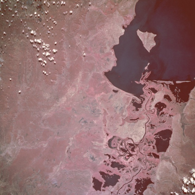 |
| STS057-104-063 Lake Mweru, Zaire and Zambia June 1993 The southern end of Lake Mweru, a large freshwater lake with a maximum depth of at least 80 feet (25 meters), is visible in this near-vertical, color infrared photograph. The lake forms part of the border between Zaire to the west and Zambia to the east. The lake, noted for its large fisheries, is part of the Bangweulu wetland system and the Luapula River, which flows northward through the lake and is a headstream of the Zaire (Congo) River. The Luapula River's main channel, south of the lake, meanders through the swampy floodplain where many open bodies of water are identified as dark features within the heavily vegetated marshland. The roughly triangular lake island near the southern end of Lake Mweru belongs to Zambia. Visible west of the lake is the northern portion of the Kundelungu Mountains, a range of low mountains and escarpments, through which a roadway winds between some of the more elevated landforms. The reddish pink color on color infrared film designates green vegetation and indicates areas with dense foliage south and west of the lake. |
| Images: | All Available Images Low-Resolution 112k |
|
| Mission: | STS057 |
|
| Roll - Frame: | 104 - 63 |
|
| Geographical Name: | ZAMBIA |
|
| Features: | LAKE MWERU SOUTH END |
|
| Center Lat x Lon: | 9.5S x 28.5E |
|
| Film Exposure: | N | N=Normal exposure, U=Under exposed, O=Over exposed, F=out of Focus |
| Percentage of Cloud Cover-CLDP: | 0 |
|
| Camera:: | HB |
|
| Camera Tilt: | 16 | LO=Low Oblique, HO=High Oblique, NV=Near Vertical |
| Camera Focal Length: | 250 |
|
| Nadir to Photo Center Direction: | SE | The direction from the nadir to the center point, N=North, S=South, E=East, W=West |
| Stereo?: | N | Y=Yes there is an adjacent picture of the same area, N=No there isn't |
| Orbit Number: | 107 |
|
| Date: | 19930628 | YYYYMMDD |
| Time: | 103123 | GMT HHMMSS |
| Nadir Lat: | 8.7S |
Latitude of suborbital point of spacecraft |
| Nadir Lon: | 27.6E |
Longitude of suborbital point of spacecraft |
| Sun Azimuth: | 352 | Clockwise angle in degrees from north to the sun measured at the nadir point |
| Space Craft Altitude: | 246 | nautical miles |
| Sun Elevation: | 58 | Angle in degrees between the horizon and the sun, measured at the nadir point |
| Land Views: | HILL, ESCARPMENT, FOREST, PLATEAU |
|
| Water Views: | LAKE, SWAMP, RIVER, DELTA |
|
| Atmosphere Views: | |
|
| Man Made Views: | |
|
| City Views: | |
|
Photo is not associated with any sequences | ||
| NASA Home Page |
JSC Home Page |
JSC Digital Image Collection |
Earth Science & Remote Sensing |
|
This service is provided by the International Space Station program and the JSC Earth Science & Remote Sensing Unit, ARES Division, Exploration Integration Science Directorate.

|