Geographic Region: NEW ZEALAND-NI
Feature: NORTH ISLAND
|
Geographic Region: NEW ZEALAND-NI Feature: NORTH ISLAND |
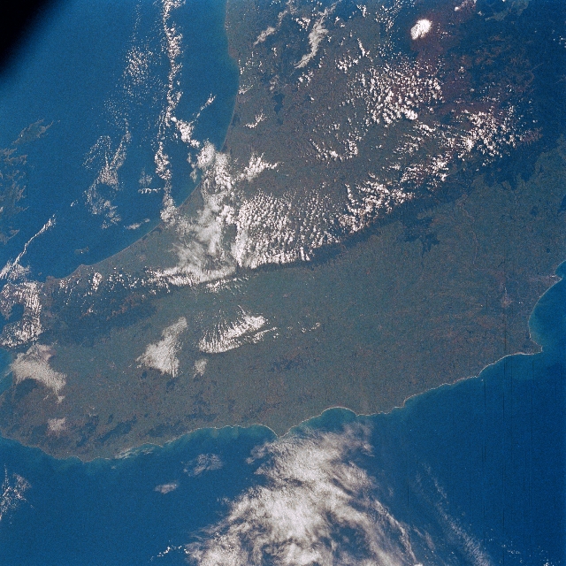 |
| STS056-098-080 Southern North Island, New Zealand April 1993 The southern portion of North Island is visible in this northwest-looking view. The broad grassland and pasture landscape, famous for cattle-raising and dairy products, covers most of the bottom half of the image. The blue-colored waters of the Pacific Ocean are prominent in the lower quarter of the view. The forest-covered Tararua, Ruahine, and Wakarara Ranges are visible from just below the left center to the upper right of the image. These ranges separate the coastal plains bordering the Pacific Ocean to the east, from the narrower coastal plains bordering the Tasman Sea to the west. The snow-covered peak in the upper right portion of the image is the stratovolcano Ruapehu, which means "explosion pit". The volcano is 9175 feet (2798 meters) high and has erupted over 50 times since 1861, the last in January 1999. Tremors and steam plumes continue today. The volcano has a crater that is filled with an acidic warm water lake. Near the right center of the image located on the shores of Hawke Bay is the city of Napier, a major wool exporting port. |
| Images: | All Available Images Low-Resolution 391k |
|
| Mission: | STS056 |
|
| Roll - Frame: | 98 - 80 |
|
| Geographical Name: | NEW ZEALAND-NI |
|
| Features: | NORTH ISLAND |
|
| Center Lat x Lon: | 40.5S x 176.0E |
|
| Film Exposure: | N | N=Normal exposure, U=Under exposed, O=Over exposed, F=out of Focus |
| Percentage of Cloud Cover-CLDP: | 10 |
|
| Camera:: | HB |
|
| Camera Tilt: | 47 | LO=Low Oblique, HO=High Oblique, NV=Near Vertical |
| Camera Focal Length: | 100 |
|
| Nadir to Photo Center Direction: | SW | The direction from the nadir to the center point, N=North, S=South, E=East, W=West |
| Stereo?: | N | Y=Yes there is an adjacent picture of the same area, N=No there isn't |
| Orbit Number: | 123 |
|
| Date: | 19930415 | YYYYMMDD |
| Time: | 220933 | GMT HHMMSS |
| Nadir Lat: | 39.1S |
Latitude of suborbital point of spacecraft |
| Nadir Lon: | 178.6E |
Longitude of suborbital point of spacecraft |
| Sun Azimuth: | 35 | Clockwise angle in degrees from north to the sun measured at the nadir point |
| Space Craft Altitude: | 166 | nautical miles |
| Sun Elevation: | 34 | Angle in degrees between the horizon and the sun, measured at the nadir point |
| Land Views: | ISLAND, VOLCANO, HILL, FOREST |
|
| Water Views: | BAY |
|
| Atmosphere Views: | |
|
| Man Made Views: | AGRICULTURE |
|
| City Views: | |
|
Photo is not associated with any sequences | ||
| NASA Home Page |
JSC Home Page |
JSC Digital Image Collection |
Earth Science & Remote Sensing |
|
This service is provided by the International Space Station program and the JSC Earth Science & Remote Sensing Unit, ARES Division, Exploration Integration Science Directorate.

|