
Geographic Region: BRAZIL
Feature: ILHA SOLTEIRA RESERVOIR
|
Geographic Region: BRAZIL Feature: ILHA SOLTEIRA RESERVOIR |
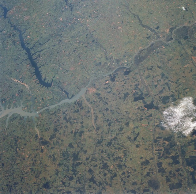 |
| STS056-098-008 Rio Paraná and Rio Tietê, Brazil April 1993 The southwestward-flowing Paraná River forms the border between the Brazilian states of São Paulo (east) and Mato Grosso (west). The photograph shows three major dams (two on the Paraná and one on the Tietê), the resultant reservoirs, a well-defined trellis drainage pattern, and a marked difference in intensity of agriculture between the two states. The trellis drainage pattern shows the Paraná River (the consequent stream) and numerous subsequent streams, including the Tietê River, entering the Paraná from east and west. The dark water of the Tietê River results from vegetal debris and not sediment; in comparison, parts of the Paraná River and several of its tributaries have brownish-tan sediment suspended in their water. The state of São Paulo shows fewer stands of forest (darker areas) than neighboring Mato Grosso, thereby indicating a more mature and widespread use of the land for the production of crops or livestock. The city of Três Lagoas lies west of the Paraná River near the center of the photograph. |
| Images: | All Available Images Low-Resolution 137k |
|
| Mission: | STS056 |
|
| Roll - Frame: | 98 - 8 |
|
| Geographical Name: | BRAZIL |
|
| Features: | ILHA SOLTEIRA RESERVOIR |
|
| Center Lat x Lon: | 20.5S x 51W |
|
| Film Exposure: | N | N=Normal exposure, U=Under exposed, O=Over exposed, F=out of Focus |
| Percentage of Cloud Cover-CLDP: | 0 |
|
| Camera:: | HB |
|
| Camera Tilt: | 42 | LO=Low Oblique, HO=High Oblique, NV=Near Vertical |
| Camera Focal Length: | 100 |
|
| Nadir to Photo Center Direction: | E | The direction from the nadir to the center point, N=North, S=South, E=East, W=West |
| Stereo?: | N | Y=Yes there is an adjacent picture of the same area, N=No there isn't |
| Orbit Number: | 101 |
|
| Date: | 19930414 | YYYYMMDD |
| Time: | 125508 | GMT HHMMSS |
| Nadir Lat: | 19.7S |
Latitude of suborbital point of spacecraft |
| Nadir Lon: | 53.3W |
Longitude of suborbital point of spacecraft |
| Sun Azimuth: | 57 | Clockwise angle in degrees from north to the sun measured at the nadir point |
| Space Craft Altitude: | 162 | nautical miles |
| Sun Elevation: | 41 | Angle in degrees between the horizon and the sun, measured at the nadir point |
| Land Views: | HILL, FOREST, UPLAND, VALLEY |
|
| Water Views: | RIVER, SEDIMENT, RESERVOIR |
|
| Atmosphere Views: | |
|
| Man Made Views: | AGRICULTURE, DAM |
|
| City Views: | |
|
Photo is not associated with any sequences | ||
| NASA Home Page |
JSC Home Page |
JSC Digital Image Collection |
Earth Science & Remote Sensing |
|
This service is provided by the International Space Station program and the JSC Earth Science & Remote Sensing Unit, ARES Division, Exploration Integration Science Directorate.

|