Geographic Region: ARGENTINA
Feature: LAKE VIEDMA,L. ARGENTINO
|
Geographic Region: ARGENTINA Feature: LAKE VIEDMA,L. ARGENTINO |
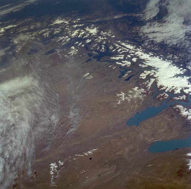 |
| STS056-098-026 Southern Andes Mountains, Argentina and Chile April 1993 The Andes Mountains terminate at the southern end of Chile and Argentina in a jumble of islands and fjords. This low-oblique, south-looking photograph shows the fragmented landscape as the South American continent gradually ends in Tierra del Fuego. Part of the Strait of Magellan is barely visible near the horizon. Numerous glacier lakes can be seen on either side of the north-south axis of the ice- and snow-covered Andes Mountains. The mountains gradually decrease in elevation, from approximately 10 000 feet (3048 meters) in this photograph to 4000 feet (1220 meters) and less above sea level near the horizon. Lake Viedma (northernmost) and Lake Argentino--the two larger light blue lakes at the northern end of the photograph--constantly receive meltwater from the western glaciers. The brownish-tan terrain east of the Andes Mountains is a plateau where the constantly blowing west wind, coupled with very limited precipitation, produces a harsh, barren, almost nonvegetated landscape in this Argentine region of Patagonia. |
| Images: | All Available Images Low-Resolution 119k |
|
| Mission: | STS056 |
|
| Roll - Frame: | 98 - 26 |
|
| Geographical Name: | ARGENTINA |
|
| Features: | LAKE VIEDMA,L. ARGENTINO |
|
| Center Lat x Lon: | 50.5S x 71.5W |
|
| Film Exposure: | N | N=Normal exposure, U=Under exposed, O=Over exposed, F=out of Focus |
| Percentage of Cloud Cover-CLDP: | 10 |
|
| Camera:: | HB |
|
| Camera Tilt: | 50 | LO=Low Oblique, HO=High Oblique, NV=Near Vertical |
| Camera Focal Length: | 100 |
|
| Nadir to Photo Center Direction: | S | The direction from the nadir to the center point, N=North, S=South, E=East, W=West |
| Stereo?: | N | Y=Yes there is an adjacent picture of the same area, N=No there isn't |
| Orbit Number: | 103 |
|
| Date: | 19930414 | YYYYMMDD |
| Time: | 160515 | GMT HHMMSS |
| Nadir Lat: | 47.3S |
Latitude of suborbital point of spacecraft |
| Nadir Lon: | 70.5W |
Longitude of suborbital point of spacecraft |
| Sun Azimuth: | 11 | Clockwise angle in degrees from north to the sun measured at the nadir point |
| Space Craft Altitude: | 167 | nautical miles |
| Sun Elevation: | 33 | Angle in degrees between the horizon and the sun, measured at the nadir point |
| Land Views: | MOUNTAIN, PLAIN, PLATEAU, GLACIER, ISLAND |
|
| Water Views: | LAKE, STRAIT, INLET, BAY |
|
| Atmosphere Views: | |
|
| Man Made Views: | |
|
| City Views: | |
|
Photo is not associated with any sequences | ||
| NASA Home Page |
JSC Home Page |
JSC Digital Image Collection |
Earth Science & Remote Sensing |
|
This service is provided by the International Space Station program and the JSC Earth Science & Remote Sensing Unit, ARES Division, Exploration Integration Science Directorate.

|