
Geographic Region: USA-FLORIDA
Feature: CITY OF MIAMI
|
Geographic Region: USA-FLORIDA Feature: CITY OF MIAMI |
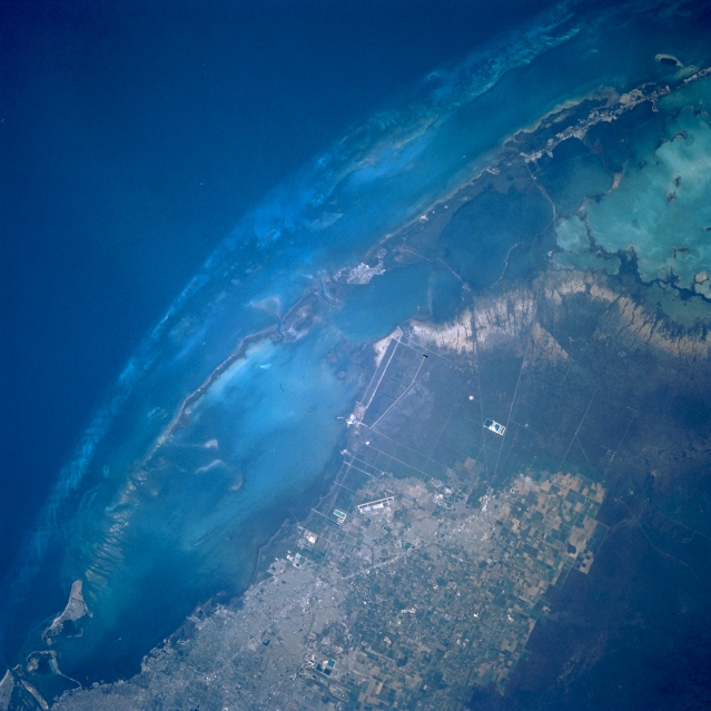 |
| STS056-097-053 Homestead, Florida, U.S.A. April 1993 The dark blue Straits of Florida, where water depths average approximately 1000 feet (305 meters), contrast with the lighter blues of much shallower Biscayne Bay and Florida Bay at the southern tip of the mainland where depths average 6 to 10 feet (2 to 3 meters). The northern end of the Florida Keys extend north to southwest of the mainland. The cultivated fields between densely populated greater Miami and the darker, more uniform Everglades grow a variety of commercially produced vegetables and fruits. Discernible are the light, linear, single runway (slightly below middle) of Homestead Air Force Base east of Homestead and a large, roughly rectangular feature along western Biscayne Bay southeast of the air base that appears to be a fish hatchery or specialized aquaculture center. Discernment is difficult between elevated ground and swampy saw grass and between permanently water covered areas of sea grass and the swampy, vegetated coastal plains. |
| Images: | All Available Images Low-Resolution 295k |
|
| Mission: | STS056 |
|
| Roll - Frame: | 97 - 53 |
|
| Geographical Name: | USA-FLORIDA |
|
| Features: | CITY OF MIAMI |
|
| Center Lat x Lon: | 25.5N x 80.5W |
|
| Film Exposure: | N | N=Normal exposure, U=Under exposed, O=Over exposed, F=out of Focus |
| Percentage of Cloud Cover-CLDP: | 0 |
|
| Camera:: | HB |
|
| Camera Tilt: | 12 | LO=Low Oblique, HO=High Oblique, NV=Near Vertical |
| Camera Focal Length: | 250 |
|
| Nadir to Photo Center Direction: | NE | The direction from the nadir to the center point, N=North, S=South, E=East, W=West |
| Stereo?: | N | Y=Yes there is an adjacent picture of the same area, N=No there isn't |
| Orbit Number: | 101 |
|
| Date: | 19930414 | YYYYMMDD |
| Time: | 124137 | GMT HHMMSS |
| Nadir Lat: | 25.1N |
Latitude of suborbital point of spacecraft |
| Nadir Lon: | 80.9W |
Longitude of suborbital point of spacecraft |
| Sun Azimuth: | 89 | Clockwise angle in degrees from north to the sun measured at the nadir point |
| Space Craft Altitude: | 161 | nautical miles |
| Sun Elevation: | 21 | Angle in degrees between the horizon and the sun, measured at the nadir point |
| Land Views: | PLAIN, ISLAND |
|
| Water Views: | BAY, OCEAN |
|
| Atmosphere Views: | |
|
| Man Made Views: | AIRPORT, AGRICULTURE |
|
| City Views: | |
|
Photo is not associated with any sequences | ||
| NASA Home Page |
JSC Home Page |
JSC Digital Image Collection |
Earth Science & Remote Sensing |
|
This service is provided by the International Space Station program and the JSC Earth Science & Remote Sensing Unit, ARES Division, Exploration Integration Science Directorate.

|