
Geographic Region: USA-FLORIDA
Feature: CITY OF MIAMI
|
Geographic Region: USA-FLORIDA Feature: CITY OF MIAMI |
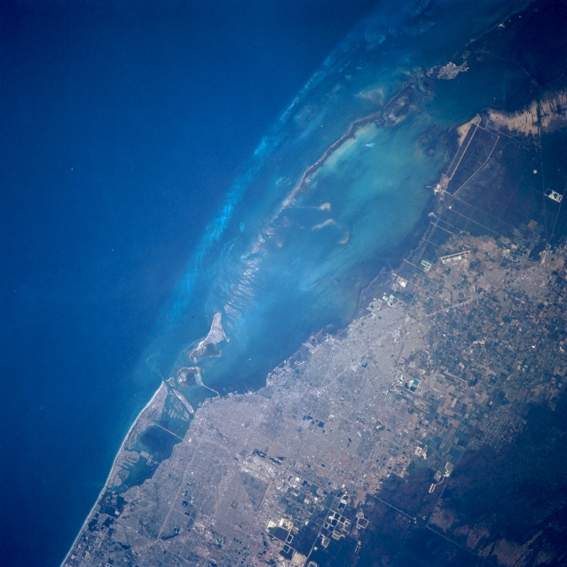 |
| STS056-097-052 Miami, Florida, U.S.A. April 1993 The dark blue Straits of Florida (the north-flowing Gulf Stream) with water depths exceeding 1000 feet (305 meters) contrast with the lighter blues of Biscayne Bay where water depths of 6 to 10 feet (2 to 3 meters) are common. At this scale few features of Miami are discernible--the runway and apron of Homestead Air Force Base south of city and large rectangular water-filled pits created by the excavation of limestone (bottom center). |
| Images: | All Available Images Low-Resolution 312k |
|
| Mission: | STS056 |
|
| Roll - Frame: | 97 - 52 |
|
| Geographical Name: | USA-FLORIDA |
|
| Features: | CITY OF MIAMI |
|
| Center Lat x Lon: | 25.5N x 80.5W |
|
| Film Exposure: | N | N=Normal exposure, U=Under exposed, O=Over exposed, F=out of Focus |
| Percentage of Cloud Cover-CLDP: | 0 |
|
| Camera:: | HB |
|
| Camera Tilt: | 12 | LO=Low Oblique, HO=High Oblique, NV=Near Vertical |
| Camera Focal Length: | 250 |
|
| Nadir to Photo Center Direction: | NE | The direction from the nadir to the center point, N=North, S=South, E=East, W=West |
| Stereo?: | N | Y=Yes there is an adjacent picture of the same area, N=No there isn't |
| Orbit Number: | 101 |
|
| Date: | 19930414 | YYYYMMDD |
| Time: | 124135 | GMT HHMMSS |
| Nadir Lat: | 25.2N |
Latitude of suborbital point of spacecraft |
| Nadir Lon: | 81W |
Longitude of suborbital point of spacecraft |
| Sun Azimuth: | 89 | Clockwise angle in degrees from north to the sun measured at the nadir point |
| Space Craft Altitude: | 161 | nautical miles |
| Sun Elevation: | 21 | Angle in degrees between the horizon and the sun, measured at the nadir point |
| Land Views: | COAST, ISLAND |
|
| Water Views: | OCEAN, BAY |
|
| Atmosphere Views: | |
|
| Man Made Views: | URBAN AREA, AIRPORT |
|
| City Views: | |
|
Photo is not associated with any sequences | ||
| NASA Home Page |
JSC Home Page |
JSC Digital Image Collection |
Earth Science & Remote Sensing |
|
This service is provided by the International Space Station program and the JSC Earth Science & Remote Sensing Unit, ARES Division, Exploration Integration Science Directorate.

|