
Geographic Region: USA-WISCONSIN
Feature: MISSISSIPPI,WISCONSIN R.
|
Geographic Region: USA-WISCONSIN Feature: MISSISSIPPI,WISCONSIN R. |
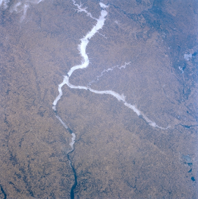 |
| STS056-080-092 Mississippi and Wisconsin Rivers; Driftless Area, Wisconsin, U.S.A. April 1993 The Driftless Area of southwestern Wisconsin, northeastern Iowa, and southeastern Minnesota is discernible in this northwest-looking, low-oblique photograph. Also referred to as the Western Upland, it is generally an agricultural region with residual, well-drained soil--a dissected (eroded) upland. The continental glacier that covered most of the surrounding regions did not touch the Driftless Area, which abounds in hilly, rugged terrain; caves; and sinkholes. Apparent are the Mississippi River Valley as far as south of Dubuque, Iowa (barely discernible near bottom center), and the Wisconsin River, which flows westward to the Mississippi River. Fog is discernible in the valleys of the Mississippi and Wisconsin Rivers and in the smaller Kickapoo River Valley (near center). |
| Images: | All Available Images Low-Resolution 355k |
|
| Mission: | STS056 |
|
| Roll - Frame: | 80 - 92 |
|
| Geographical Name: | USA-WISCONSIN |
|
| Features: | MISSISSIPPI,WISCONSIN R. |
|
| Center Lat x Lon: | 43.0N x 91W |
|
| Film Exposure: | N | N=Normal exposure, U=Under exposed, O=Over exposed, F=out of Focus |
| Percentage of Cloud Cover-CLDP: | 5 |
|
| Camera:: | HB |
|
| Camera Tilt: | 29 | LO=Low Oblique, HO=High Oblique, NV=Near Vertical |
| Camera Focal Length: | 100 |
|
| Nadir to Photo Center Direction: | N | The direction from the nadir to the center point, N=North, S=South, E=East, W=West |
| Stereo?: | N | Y=Yes there is an adjacent picture of the same area, N=No there isn't |
| Orbit Number: | 38 |
|
| Date: | 19930410 | YYYYMMDD |
| Time: | 134150 | GMT HHMMSS |
| Nadir Lat: | 41.5N |
Latitude of suborbital point of spacecraft |
| Nadir Lon: | 91W |
Longitude of suborbital point of spacecraft |
| Sun Azimuth: | 100 | Clockwise angle in degrees from north to the sun measured at the nadir point |
| Space Craft Altitude: | 163 | nautical miles |
| Sun Elevation: | 23 | Angle in degrees between the horizon and the sun, measured at the nadir point |
| Land Views: | HILL |
|
| Water Views: | RIVER |
|
| Atmosphere Views: | FOG |
|
| Man Made Views: | |
|
| City Views: | |
|
Photo is not associated with any sequences | ||
| NASA Home Page |
JSC Home Page |
JSC Digital Image Collection |
Earth Science & Remote Sensing |
|
This service is provided by the International Space Station program and the JSC Earth Science & Remote Sensing Unit, ARES Division, Exploration Integration Science Directorate.

|