
Geographic Region: GREECE
Feature: KHALKIDHIKI PEN.,LAKES
|
Geographic Region: GREECE Feature: KHALKIDHIKI PEN.,LAKES |
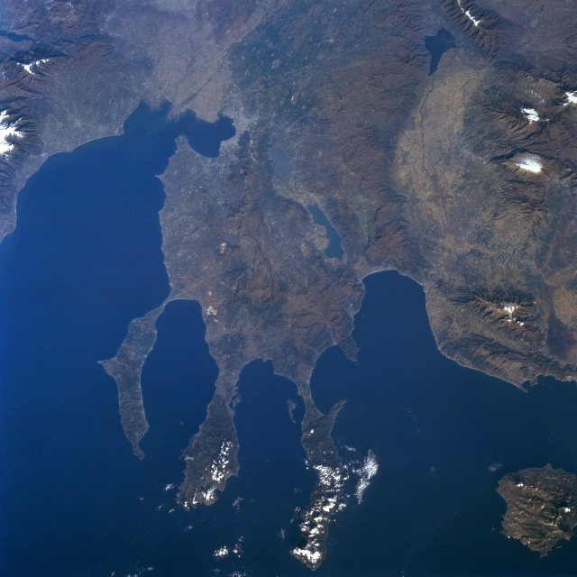 |
| STS056-079-038 Chalcidice Peninsula, Greece April 1993 The rugged Chalcidice (Khalkidhiki) Peninsula of northeast Greece projects into the Aegean Sea (bottom left of image) in this west looking view. The peninsula lies between the Strymonic Gulf to the east (right) and the Gulf of Salonika to the west (left). Although the Chalcidice Peninsula is largely mountainous and dry, agricultural products include olive oil, wine, wheat, and tobacco. In ancient times, the peninsula was famous for its timber. The main peninsula terminates in three more narrow peninsulas: Acte (west), Sithonia (center), and Kassandra (east). Lake Koronia is visible near the center of the image. The smaller lake west of Lake Koronia is Lake Bolbe. Thasos Island is visible under scattered clouds at the lower right portion of the image. |
| Images: | All Available Images Low-Resolution 308k |
|
| Mission: | STS056 |
|
| Roll - Frame: | 79 - 38 |
|
| Geographical Name: | GREECE |
|
| Features: | KHALKIDHIKI PEN.,LAKES |
|
| Center Lat x Lon: | 40.5N x 23.5E |
|
| Film Exposure: | N | N=Normal exposure, U=Under exposed, O=Over exposed, F=out of Focus |
| Percentage of Cloud Cover-CLDP: | 5 |
|
| Camera:: | HB |
|
| Camera Tilt: | 22 | LO=Low Oblique, HO=High Oblique, NV=Near Vertical |
| Camera Focal Length: | 100 |
|
| Nadir to Photo Center Direction: | W | The direction from the nadir to the center point, N=North, S=South, E=East, W=West |
| Stereo?: | N | Y=Yes there is an adjacent picture of the same area, N=No there isn't |
| Orbit Number: | 33 |
|
| Date: | 19930410 | YYYYMMDD |
| Time: | 061018 | GMT HHMMSS |
| Nadir Lat: | 40.7N |
Latitude of suborbital point of spacecraft |
| Nadir Lon: | 24.6E |
Longitude of suborbital point of spacecraft |
| Sun Azimuth: | 102 | Clockwise angle in degrees from north to the sun measured at the nadir point |
| Space Craft Altitude: | 163 | nautical miles |
| Sun Elevation: | 25 | Angle in degrees between the horizon and the sun, measured at the nadir point |
| Land Views: | PENINSULA, ISLAND, MOUNTAIN, FAULT |
|
| Water Views: | SEA, LAKE, GULF |
|
| Atmosphere Views: | |
|
| Man Made Views: | |
|
| City Views: | |
|
Photo is not associated with any sequences | ||
| NASA Home Page |
JSC Home Page |
JSC Digital Image Collection |
Earth Science & Remote Sensing |
|
This service is provided by the International Space Station program and the JSC Earth Science & Remote Sensing Unit, ARES Division, Exploration Integration Science Directorate.

|