
Geographic Region: TURKEY
Feature: IMPOZ ISLAND,HAZE
|
Geographic Region: TURKEY Feature: IMPOZ ISLAND,HAZE |
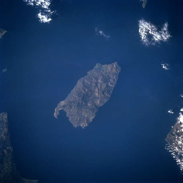 |
| STS056-078-034 Imroz Island, Turkey April 1993 Located in the northeast Aegean Sea near the entrance to Dardanelles, the island of Imroz can be seen in this near-nadir looking view. The island covering 108 sq. miles (280 sq. km) has hilly terrain with numerous small canyons and valleys. Grains and beans are grown on the island. Fishing is also a major occupation. |
| Images: | All Available Images Low-Resolution 246k |
|
| Mission: | STS056 |
|
| Roll - Frame: | 78 - 34 |
|
| Geographical Name: | TURKEY |
|
| Features: | IMPOZ ISLAND,HAZE |
|
| Center Lat x Lon: | 40.0N x 26.0E |
|
| Film Exposure: | N | N=Normal exposure, U=Under exposed, O=Over exposed, F=out of Focus |
| Percentage of Cloud Cover-CLDP: | 10 |
|
| Camera:: | HB |
|
| Camera Tilt: | 10 | LO=Low Oblique, HO=High Oblique, NV=Near Vertical |
| Camera Focal Length: | 250 |
|
| Nadir to Photo Center Direction: | E | The direction from the nadir to the center point, N=North, S=South, E=East, W=West |
| Stereo?: | Y | Y=Yes there is an adjacent picture of the same area, N=No there isn't |
| Orbit Number: | 33 |
|
| Date: | 19930410 | YYYYMMDD |
| Time: | 061020 | GMT HHMMSS |
| Nadir Lat: | 40.0N |
Latitude of suborbital point of spacecraft |
| Nadir Lon: | 25.5E |
Longitude of suborbital point of spacecraft |
| Sun Azimuth: | 102 | Clockwise angle in degrees from north to the sun measured at the nadir point |
| Space Craft Altitude: | 163 | nautical miles |
| Sun Elevation: | 26 | Angle in degrees between the horizon and the sun, measured at the nadir point |
| Land Views: | ISLAND, HILL |
|
| Water Views: | SEA |
|
| Atmosphere Views: | |
|
| Man Made Views: | |
|
| City Views: | |
|
Photo is not associated with any sequences | ||
| NASA Home Page |
JSC Home Page |
JSC Digital Image Collection |
Earth Science & Remote Sensing |
|
This service is provided by the International Space Station program and the JSC Earth Science & Remote Sensing Unit, ARES Division, Exploration Integration Science Directorate.

|