
Geographic Region: USA-TEXAS
Feature: BROWNSVILLE,LAGUNA MADRE
|
Geographic Region: USA-TEXAS Feature: BROWNSVILLE,LAGUNA MADRE |
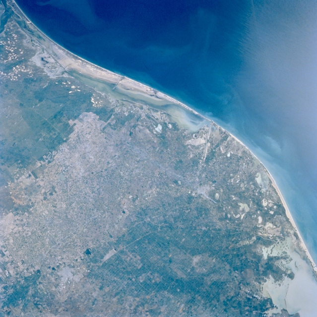 |
| STS056-077-061 Rio Grande Delta, Texas, U.S.A. April 1993 The flat floodplain of the Rio Grande and a large part of its delta are visible in this synoptic photograph of the southern tip of Texas. The diverse coastal area includes tidal flats; sand dunes; floodplain deposits; and Laguna Madre, whose shallowness allows small waves to keep the sand in suspension, thereby producing a sandy-looking water. The Intracoastal Waterway between Padre Island and the mainland requires constant dredging to keep it and other channels open for ship traffic. The northern part of Mexico's highly reflective Laguna Madre is visible (lower right corner). The speckled landscape (upper left edge) shows nonvegetated sand dunes; darker areas denote sandy soils where vegetative cover provides some stability for the shifting sands; and the lighter inland areas show the greatest concentration of agricultural activity, primarily north of the United States-Mexico border. |
| Images: | All Available Images Low-Resolution 347k |
|
| Mission: | STS056 |
|
| Roll - Frame: | 77 - 61 |
|
| Geographical Name: | USA-TEXAS |
|
| Features: | BROWNSVILLE,LAGUNA MADRE |
|
| Center Lat x Lon: | 26.5N x 97.5W |
|
| Film Exposure: | N | N=Normal exposure, U=Under exposed, O=Over exposed, F=out of Focus |
| Percentage of Cloud Cover-CLDP: | 0 |
|
| Camera:: | HB |
|
| Camera Tilt: | 27 | LO=Low Oblique, HO=High Oblique, NV=Near Vertical |
| Camera Focal Length: | 100 |
|
| Nadir to Photo Center Direction: | NE | The direction from the nadir to the center point, N=North, S=South, E=East, W=West |
| Stereo?: | N | Y=Yes there is an adjacent picture of the same area, N=No there isn't |
| Orbit Number: | 39 |
|
| Date: | 19930410 | YYYYMMDD |
| Time: | 151729 | GMT HHMMSS |
| Nadir Lat: | 25.6N |
Latitude of suborbital point of spacecraft |
| Nadir Lon: | 98.5W |
Longitude of suborbital point of spacecraft |
| Sun Azimuth: | 101 | Clockwise angle in degrees from north to the sun measured at the nadir point |
| Space Craft Altitude: | 161 | nautical miles |
| Sun Elevation: | 40 | Angle in degrees between the horizon and the sun, measured at the nadir point |
| Land Views: | COAST, PLAIN, DUNE |
|
| Water Views: | GULF, LAGOON |
|
| Atmosphere Views: | |
|
| Man Made Views: | AGRICULTURE |
|
| City Views: | |
|
Photo is not associated with any sequences | ||
| NASA Home Page |
JSC Home Page |
JSC Digital Image Collection |
Earth Science & Remote Sensing |
|
This service is provided by the International Space Station program and the JSC Earth Science & Remote Sensing Unit, ARES Division, Exploration Integration Science Directorate.

|