
Geographic Region: USA-TEXAS
Feature: AMISTAD RES.,PECOS RIVER
|
Geographic Region: USA-TEXAS Feature: AMISTAD RES.,PECOS RIVER |
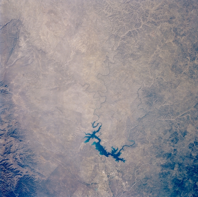 |
| STS056-077-051 International Amistad Reservoir, Texas, U.S.A. April 1993 Serpentine International Amistad Reservoir, part of the Amistad National Recreation Area, receives water from three meandering rivers--Rio Grande; Pecos, which enters the Rio Grande west of the reservoir; and Devils to the east. Steep canyons have been created by erosion of the Pecos River and Devils River. Along the Rio Grande near Del Rio (not discernible), ground surface is composed of limestone and white beds of caliche. Most of the landscape north of the Rio Grande forms the western edge of the Edwards Plateau, with vegetation consisting primarily of grass prairies and oak, cedar, and mesquite woodlands. Foothills of the Serranias del Burro (a small mountain range in Mexico) are visible (lower left corner). |
| Images: | All Available Images Low-Resolution 343k |
|
| Mission: | STS056 |
|
| Roll - Frame: | 77 - 51 |
|
| Geographical Name: | USA-TEXAS |
|
| Features: | AMISTAD RES.,PECOS RIVER |
|
| Center Lat x Lon: | 30.0N x 101.5W |
|
| Film Exposure: | N | N=Normal exposure, U=Under exposed, O=Over exposed, F=out of Focus |
| Percentage of Cloud Cover-CLDP: | 0 |
|
| Camera:: | HB |
|
| Camera Tilt: | 8 | LO=Low Oblique, HO=High Oblique, NV=Near Vertical |
| Camera Focal Length: | 100 |
|
| Nadir to Photo Center Direction: | NE | The direction from the nadir to the center point, N=North, S=South, E=East, W=West |
| Stereo?: | Y | Y=Yes there is an adjacent picture of the same area, N=No there isn't |
| Orbit Number: | 39 |
|
| Date: | 19930410 | YYYYMMDD |
| Time: | 151609 | GMT HHMMSS |
| Nadir Lat: | 29.8N |
Latitude of suborbital point of spacecraft |
| Nadir Lon: | 101.8W |
Longitude of suborbital point of spacecraft |
| Sun Azimuth: | 102 | Clockwise angle in degrees from north to the sun measured at the nadir point |
| Space Craft Altitude: | 161 | nautical miles |
| Sun Elevation: | 36 | Angle in degrees between the horizon and the sun, measured at the nadir point |
| Land Views: | RANGE |
|
| Water Views: | RESERVOIR, RIVER |
|
| Atmosphere Views: | |
|
| Man Made Views: | |
|
| City Views: | |
|
Photo is not associated with any sequences | ||
| NASA Home Page |
JSC Home Page |
JSC Digital Image Collection |
Earth Science & Remote Sensing |
|
This service is provided by the International Space Station program and the JSC Earth Science & Remote Sensing Unit, ARES Division, Exploration Integration Science Directorate.

|