
Geographic Region: USA-NEW MEXICO
Feature: SIERRA BLANCA,LAVA FIELD
|
Geographic Region: USA-NEW MEXICO Feature: SIERRA BLANCA,LAVA FIELD |
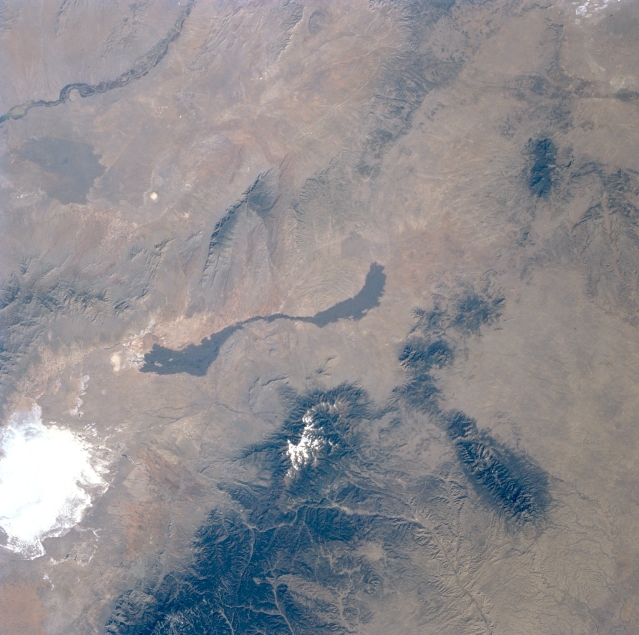 |
| STS056-077-037 Tularosa Valley, New Mexico, U.S.A. April 1993 A large section of the Tularosa Valley, sandwiched between the north-south-trending San Andres Mountains to the west and the heavily forested Sacramento and Sierra Blanca Mountains to the east, is featured in this northwest-looking, low-oblique photograph of south-central New Mexico. Visible in the valley are White Sands National Monument, the highly reflective gypsum desert; a black, ribbonlike youthful lava flow, which originated from a small volcanic center (Little Black Peak) at the north end of the flow that erupted fewer than 1000 years ago; and snowcapped Sierra Blanca Peak [12 003 feet (3659 meters)]. Visible is a drainage basin created by the Hondo River as it erodes the eastern slopes of the Sacramento Mountains and the southern slopes of the east-west-oriented Capitan Mountains (lower right edge of the photograph). A small section of the Rio Grande is apparent (upper left corner), and an older lava flow is barely discernible to its east. |
| Images: | All Available Images Low-Resolution 314k |
|
| Mission: | STS056 |
|
| Roll - Frame: | 77 - 37 |
|
| Geographical Name: | USA-NEW MEXICO |
|
| Features: | SIERRA BLANCA,LAVA FIELD |
|
| Center Lat x Lon: | 33.5N x 106W |
|
| Film Exposure: | N | N=Normal exposure, U=Under exposed, O=Over exposed, F=out of Focus |
| Percentage of Cloud Cover-CLDP: | 0 |
|
| Camera:: | HB |
|
| Camera Tilt: | 14 | LO=Low Oblique, HO=High Oblique, NV=Near Vertical |
| Camera Focal Length: | 100 |
|
| Nadir to Photo Center Direction: | SW | The direction from the nadir to the center point, N=North, S=South, E=East, W=West |
| Stereo?: | Y | Y=Yes there is an adjacent picture of the same area, N=No there isn't |
| Orbit Number: | 39 |
|
| Date: | 19930410 | YYYYMMDD |
| Time: | 151450 | GMT HHMMSS |
| Nadir Lat: | 33.8N |
Latitude of suborbital point of spacecraft |
| Nadir Lon: | 105.4W |
Longitude of suborbital point of spacecraft |
| Sun Azimuth: | 102 | Clockwise angle in degrees from north to the sun measured at the nadir point |
| Space Craft Altitude: | 162 | nautical miles |
| Sun Elevation: | 32 | Angle in degrees between the horizon and the sun, measured at the nadir point |
| Land Views: | VALLEY, DESERT, VOLCANO, MOUNTAIN |
|
| Water Views: | |
|
| Atmosphere Views: | |
|
| Man Made Views: | |
|
| City Views: | |
|
Photo is not associated with any sequences | ||
| NASA Home Page |
JSC Home Page |
JSC Digital Image Collection |
Earth Science & Remote Sensing |
|
This service is provided by the International Space Station program and the JSC Earth Science & Remote Sensing Unit, ARES Division, Exploration Integration Science Directorate.

|