
Geographic Region: USA-NEW MEXICO
Feature: SIERRA BLANCA,LAVA FIELD
|
Geographic Region: USA-NEW MEXICO Feature: SIERRA BLANCA,LAVA FIELD |
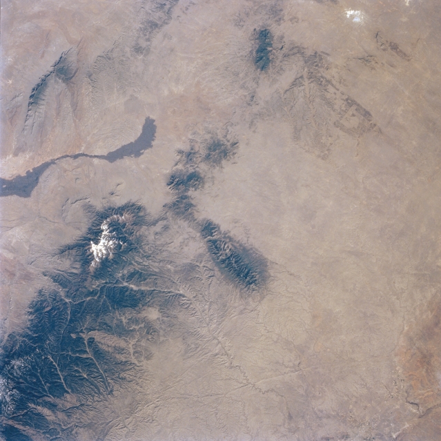 |
| STS056-077-036 Sacramento Mountains, New Mexico, U.S.A. April 1993 The forested Sacramento and Sierra Blanca Mountains (lower left) of central New Mexico form the eastern edge of the Rio Grande Rift Valley, a rift zone that extends north-south through central New Mexico. Snowcapped Sierra Blanca Peak rises 12 003 feet (3659 meters). Fewer than 1000 years ago, lava erupted from Little Black Peak, a tiny volcanic center at the northern end of the dark, smooth, somewhat linear lava flow (left center). A partial view of the Hondo River drainage basin appears south of the east-west aligned Capitan Mountains (center of the photograph. |
| Images: | All Available Images Low-Resolution 312k |
|
| Mission: | STS056 |
|
| Roll - Frame: | 77 - 36 |
|
| Geographical Name: | USA-NEW MEXICO |
|
| Features: | SIERRA BLANCA,LAVA FIELD |
|
| Center Lat x Lon: | 33.5N x 105.5W |
|
| Film Exposure: | N | N=Normal exposure, U=Under exposed, O=Over exposed, F=out of Focus |
| Percentage of Cloud Cover-CLDP: | 0 |
|
| Camera:: | HB |
|
| Camera Tilt: | 11 | LO=Low Oblique, HO=High Oblique, NV=Near Vertical |
| Camera Focal Length: | 100 |
|
| Nadir to Photo Center Direction: | S | The direction from the nadir to the center point, N=North, S=South, E=East, W=West |
| Stereo?: | Y | Y=Yes there is an adjacent picture of the same area, N=No there isn't |
| Orbit Number: | 39 |
|
| Date: | 19930410 | YYYYMMDD |
| Time: | 151447 | GMT HHMMSS |
| Nadir Lat: | 34.0N |
Latitude of suborbital point of spacecraft |
| Nadir Lon: | 105.6W |
Longitude of suborbital point of spacecraft |
| Sun Azimuth: | 102 | Clockwise angle in degrees from north to the sun measured at the nadir point |
| Space Craft Altitude: | 162 | nautical miles |
| Sun Elevation: | 31 | Angle in degrees between the horizon and the sun, measured at the nadir point |
| Land Views: | MOUNTAIN, DESERT, VOLCANO |
|
| Water Views: | |
|
| Atmosphere Views: | |
|
| Man Made Views: | |
|
| City Views: | |
|
Photo is not associated with any sequences | ||
| NASA Home Page |
JSC Home Page |
JSC Digital Image Collection |
Earth Science & Remote Sensing |
|
This service is provided by the International Space Station program and the JSC Earth Science & Remote Sensing Unit, ARES Division, Exploration Integration Science Directorate.

|