
Geographic Region: USA-FLORIDA
Feature: STUART,L. OCKEECHOBEE
|
Geographic Region: USA-FLORIDA Feature: STUART,L. OCKEECHOBEE |
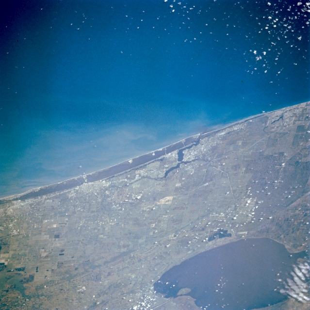 |
| STS056-076-027 Fort Pierce, Florida, U.S.A. April 1993 The land corridor between Lake Okeechobee and the Atlantic Ocean is captured in this southeast-looking photograph of the east coast of Florida from Jupiter (south) to Vero Beach (north). Several small coastal cities--Stuart, Jensen Beach, and Port Salerno--are adjacent to an embayment (near center) that provides the entrance to the eastern leg of the Okeechobee Waterway via the light, linear Saint Lucie Canal. The east-west-oriented canal between the lake and the ocean provides a navigable route across the peninsula of Florida. |
| Images: | All Available Images Low-Resolution 314k |
|
| Mission: | STS056 |
|
| Roll - Frame: | 76 - 27 |
|
| Geographical Name: | USA-FLORIDA |
|
| Features: | STUART,L. OCKEECHOBEE |
|
| Center Lat x Lon: | 27.0N x 80W |
|
| Film Exposure: | N | N=Normal exposure, U=Under exposed, O=Over exposed, F=out of Focus |
| Percentage of Cloud Cover-CLDP: | 20 |
|
| Camera:: | HB |
|
| Camera Tilt: | 45 | LO=Low Oblique, HO=High Oblique, NV=Near Vertical |
| Camera Focal Length: | 250 |
|
| Nadir to Photo Center Direction: | SW | The direction from the nadir to the center point, N=North, S=South, E=East, W=West |
| Stereo?: | N | Y=Yes there is an adjacent picture of the same area, N=No there isn't |
| Orbit Number: | 38 |
|
| Date: | 19930410 | YYYYMMDD |
| Time: | 134612 | GMT HHMMSS |
| Nadir Lat: | 28.4N |
Latitude of suborbital point of spacecraft |
| Nadir Lon: | 77.7W |
Longitude of suborbital point of spacecraft |
| Sun Azimuth: | 102 | Clockwise angle in degrees from north to the sun measured at the nadir point |
| Space Craft Altitude: | 161 | nautical miles |
| Sun Elevation: | 38 | Angle in degrees between the horizon and the sun, measured at the nadir point |
| Land Views: | PLAIN |
|
| Water Views: | LAKE, OCEAN, CANAL |
|
| Atmosphere Views: | |
|
| Man Made Views: | URBAN AREA |
|
| City Views: | |
|
Photo is not associated with any sequences | ||
| NASA Home Page |
JSC Home Page |
JSC Digital Image Collection |
Earth Science & Remote Sensing |
|
This service is provided by the International Space Station program and the JSC Earth Science & Remote Sensing Unit, ARES Division, Exploration Integration Science Directorate.

|