
Geographic Region: USA-SOUTH CAROLINA
Feature: SAVANNAH R.,TOWNS,AGR.
|
Geographic Region: USA-SOUTH CAROLINA Feature: SAVANNAH R.,TOWNS,AGR. |
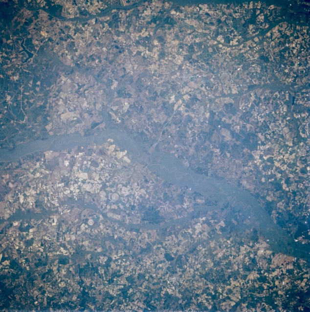 |
| STS056-076-013 Savannah River, Georgia and South Carolina, U.S.A. April 1993 The dark, heavily vegetated northwest-southeast-trending floodplain of the Savannah River is discernible across the rural terrain of eastern Georgia and southern South Carolina. The matted look of the landscape results from agricultural activities (varisized lighter areas) and darker, forested lands. Several circular cultivated field patterns indicate the use of center-pivot irrigation for farming. Southwest of the dark Salkehatchie River floodplain (top of photograph) is the U. S. Highway 301 bridge (barely visible left of center) that crosses the Savannah River northwest of Savannah and connects the small rural communities of Allendale, South Carolina, and Sylvania, Georgia. |
| Images: | All Available Images Low-Resolution 402k |
|
| Mission: | STS056 |
|
| Roll - Frame: | 76 - 13 |
|
| Geographical Name: | USA-SOUTH CAROLINA |
|
| Features: | SAVANNAH R.,TOWNS,AGR. |
|
| Center Lat x Lon: | 33.0N x 81.5W |
|
| Film Exposure: | N | N=Normal exposure, U=Under exposed, O=Over exposed, F=out of Focus |
| Percentage of Cloud Cover-CLDP: | 0 |
|
| Camera:: | HB |
|
| Camera Tilt: | 2 | LO=Low Oblique, HO=High Oblique, NV=Near Vertical |
| Camera Focal Length: | 250 |
|
| Nadir to Photo Center Direction: | E | The direction from the nadir to the center point, N=North, S=South, E=East, W=West |
| Stereo?: | Y | Y=Yes there is an adjacent picture of the same area, N=No there isn't |
| Orbit Number: | 38 |
|
| Date: | 19930410 | YYYYMMDD |
| Time: | 134443 | GMT HHMMSS |
| Nadir Lat: | 33.0N |
Latitude of suborbital point of spacecraft |
| Nadir Lon: | 81.6W |
Longitude of suborbital point of spacecraft |
| Sun Azimuth: | 103 | Clockwise angle in degrees from north to the sun measured at the nadir point |
| Space Craft Altitude: | 162 | nautical miles |
| Sun Elevation: | 33 | Angle in degrees between the horizon and the sun, measured at the nadir point |
| Land Views: | FLOOD PLAIN |
|
| Water Views: | RIVER |
|
| Atmosphere Views: | |
|
| Man Made Views: | |
|
| City Views: | |
|
Photo is not associated with any sequences | ||
| NASA Home Page |
JSC Home Page |
JSC Digital Image Collection |
Earth Science & Remote Sensing |
|
This service is provided by the International Space Station program and the JSC Earth Science & Remote Sensing Unit, ARES Division, Exploration Integration Science Directorate.

|