
Geographic Region: USA-GEORGIA
Feature: AUGUSTA,SAVANNAH R.
|
Geographic Region: USA-GEORGIA Feature: AUGUSTA,SAVANNAH R. |
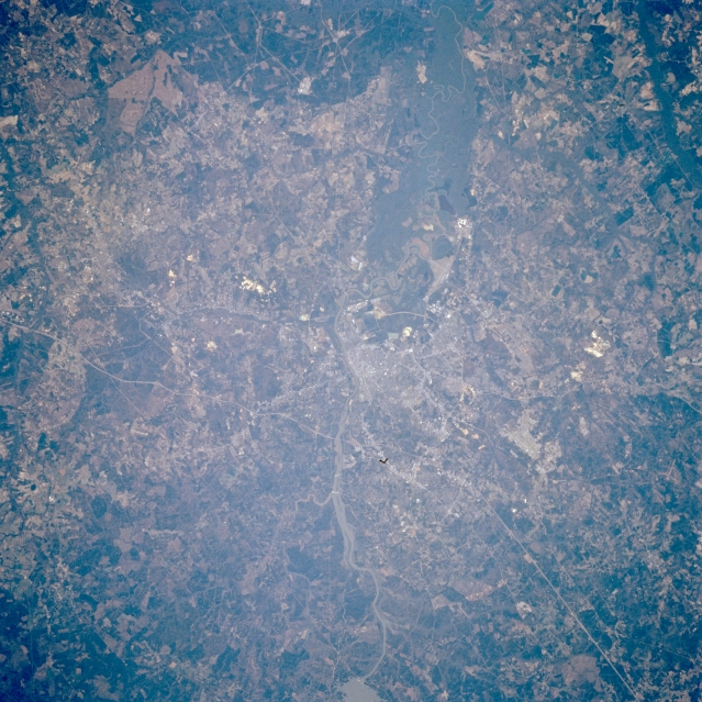 |
| STS056-076-010 Augusta, Georgia, U.S.A. April 1993 The street grid pattern of Augusta, barely discernible in the center of the photograph, is obscured by widespread vegetation and foliage. Visible are a section of the southeast-flowing Savannah River and a segment of thin, linear Interstate Highway 20 north of Augusta, which connects Augusta with Atlanta to the west and with Columbia, South Carolina, to the northeast. The dark floodplain of the Savannah River widens dramatically south of Augusta. The concentration of dark, forested land (right side of photograph) is part of the extensive Savannah River Nuclear Power Generating Facility. |
| Images: | All Available Images Low-Resolution 384k |
|
| Mission: | STS056 |
|
| Roll - Frame: | 76 - 10 |
|
| Geographical Name: | USA-GEORGIA |
|
| Features: | AUGUSTA,SAVANNAH R. |
|
| Center Lat x Lon: | 33.5N x 82W |
|
| Film Exposure: | N | N=Normal exposure, U=Under exposed, O=Over exposed, F=out of Focus |
| Percentage of Cloud Cover-CLDP: | 0 |
|
| Camera:: | HB |
|
| Camera Tilt: | 5 | LO=Low Oblique, HO=High Oblique, NV=Near Vertical |
| Camera Focal Length: | 250 |
|
| Nadir to Photo Center Direction: | SE | The direction from the nadir to the center point, N=North, S=South, E=East, W=West |
| Stereo?: | Y | Y=Yes there is an adjacent picture of the same area, N=No there isn't |
| Orbit Number: | 38 |
|
| Date: | 19930410 | YYYYMMDD |
| Time: | 134431 | GMT HHMMSS |
| Nadir Lat: | 33.6N |
Latitude of suborbital point of spacecraft |
| Nadir Lon: | 82.2W |
Longitude of suborbital point of spacecraft |
| Sun Azimuth: | 102 | Clockwise angle in degrees from north to the sun measured at the nadir point |
| Space Craft Altitude: | 162 | nautical miles |
| Sun Elevation: | 32 | Angle in degrees between the horizon and the sun, measured at the nadir point |
| Land Views: | FOREST |
|
| Water Views: | RIVER, RESERVOIR |
|
| Atmosphere Views: | |
|
| Man Made Views: | URBAN AREA, HIGHWAY |
|
| City Views: | AUGUSTA |
|
Photo is not associated with any sequences | ||
| NASA Home Page |
JSC Home Page |
JSC Digital Image Collection |
Earth Science & Remote Sensing |
|
This service is provided by the International Space Station program and the JSC Earth Science & Remote Sensing Unit, ARES Division, Exploration Integration Science Directorate.

|