
Geographic Region: PERU
Feature: COAST RIVERS,AGR.,ANDES
|
Geographic Region: PERU Feature: COAST RIVERS,AGR.,ANDES |
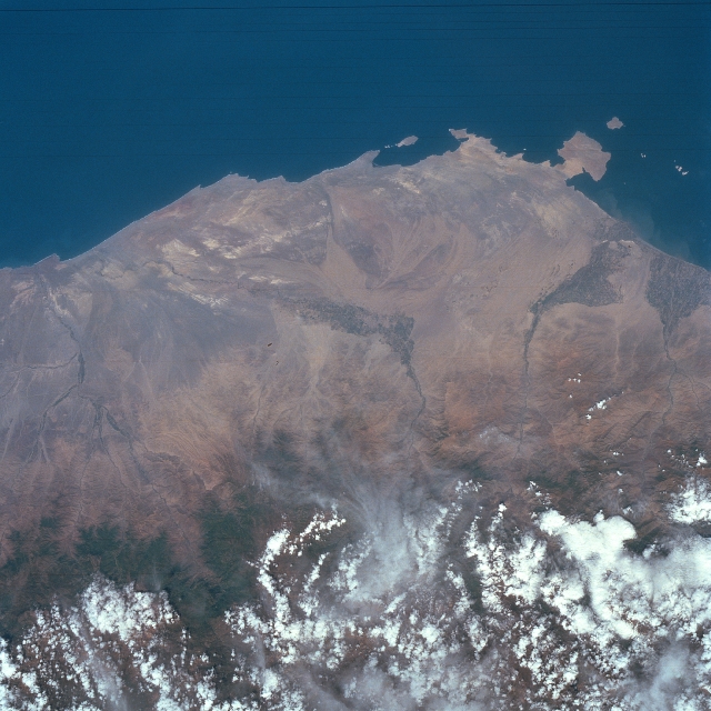 |
| STS056-075-035 Coastal Area Around Pisco, Peru April 1993 The narrow, arid but elevated coastal plains of southern Peru are visible in this image that extends inland from the Pacific coast to the western flank of the Andes Mountains (mainly obscured by white clouds at the bottom of the image). Several ephemeral stream channels can be identified as they drain generally westward. The darker-looking landscape along the streams are cultivated, irrigated regions where mainly cotton and grapes are grown. The square-looking peninsula toward the upper right corner of the picture is Pararas Peninsula. The coastal port city of Pisco is located a few miles north of the peninsula near the mouth of the Pisco River (along the first stream channel to the right of the peninsula). The Ica River Valley drains southward near the center of the image. The climate along the section of the Peruvian coast is desert, but some moisture is provided by the seasonal snowmelt from the Andes Mountains. |
| Images: | All Available Images Low-Resolution 330k |
|
| Mission: | STS056 |
|
| Roll - Frame: | 75 - 35 |
|
| Geographical Name: | PERU |
|
| Features: | COAST RIVERS,AGR.,ANDES |
|
| Center Lat x Lon: | 14.5S x 76W |
|
| Film Exposure: | N | N=Normal exposure, U=Under exposed, O=Over exposed, F=out of Focus |
| Percentage of Cloud Cover-CLDP: | 25 |
|
| Camera:: | HB |
|
| Camera Tilt: | 40 | LO=Low Oblique, HO=High Oblique, NV=Near Vertical |
| Camera Focal Length: | 100 |
|
| Nadir to Photo Center Direction: | S | The direction from the nadir to the center point, N=North, S=South, E=East, W=West |
| Stereo?: | Y | Y=Yes there is an adjacent picture of the same area, N=No there isn't |
| Orbit Number: | 39 |
|
| Date: | 19930410 | YYYYMMDD |
| Time: | 152903 | GMT HHMMSS |
| Nadir Lat: | 12.5S |
Latitude of suborbital point of spacecraft |
| Nadir Lon: | 75W |
Longitude of suborbital point of spacecraft |
| Sun Azimuth: | 49 | Clockwise angle in degrees from north to the sun measured at the nadir point |
| Space Craft Altitude: | 161 | nautical miles |
| Sun Elevation: | 59 | Angle in degrees between the horizon and the sun, measured at the nadir point |
| Land Views: | PLAIN, MOUNTAIN |
|
| Water Views: | RIVER |
|
| Atmosphere Views: | |
|
| Man Made Views: | AGRICULTURE |
|
| City Views: | |
|
Photo is not associated with any sequences | ||
| NASA Home Page |
JSC Home Page |
JSC Digital Image Collection |
Earth Science & Remote Sensing |
|
This service is provided by the International Space Station program and the JSC Earth Science & Remote Sensing Unit, ARES Division, Exploration Integration Science Directorate.

|