Geographic Region: PERU
Feature: SECHURA DESERT,LAKES
|
Geographic Region: PERU Feature: SECHURA DESERT,LAKES |
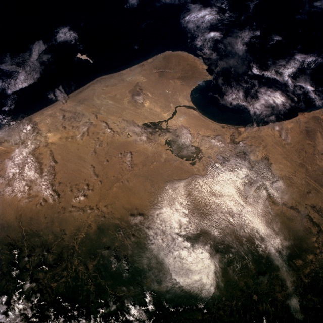 |
| STS056-075-015 Sechura Desert, Peru April 1993 The Sechura Desert of northwestern Peru is typical of the hyperarid conditions that exist along the west coast of South America where the cold Humboldt (Peruvian) Current generates very little precipitation, especially along the northern coast of Chile and the entire coast of Peru. The tan landscape is almost devoid of any vegetation, except for limited areas where sufficient moisture exists to sustain some growth. The faint wind streaks show the prevailing southwest-to-northeast wind throughout the desert. A low mountain [1580 feet (480 meters)] is barely visible on the peninsula that juts into the cold Pacific Ocean. The darker area in the desert southeast of Sechura Bay appears to be an oasis area where possibly a hardy variety of cotton is grown with the use of irrigation. This photograph demonstrates the importance of elevation by the increase in vegetative cover (darker area along the eastern side of the photograph) as the land begins its ascent into the Andes Mountains. The west-flowing Cascajal River exits the Andes Mountains, begins its trek across the Sechura Desert, and apparently disappears beneath the sandy soil of the desert before reaching the cultivated field near the coast. The south-flowing Piura River, partially obscured by clouds, can also be seen as it traverses the desert. Both of these rivers flow only when there is sufficient icemelt or snowmelt from the Andes Mountains or precipitation. |
| Images: | All Available Images Low-Resolution 116k |
|
| Mission: | STS056 |
|
| Roll - Frame: | 75 - 15 |
|
| Geographical Name: | PERU |
|
| Features: | SECHURA DESERT,LAKES |
|
| Center Lat x Lon: | 5.5S x 80.5W |
|
| Film Exposure: | N | N=Normal exposure, U=Under exposed, O=Over exposed, F=out of Focus |
| Percentage of Cloud Cover-CLDP: | 40 |
|
| Camera:: | HB |
|
| Camera Tilt: | 23 | LO=Low Oblique, HO=High Oblique, NV=Near Vertical |
| Camera Focal Length: | 100 |
|
| Nadir to Photo Center Direction: | SW | The direction from the nadir to the center point, N=North, S=South, E=East, W=West |
| Stereo?: | Y | Y=Yes there is an adjacent picture of the same area, N=No there isn't |
| Orbit Number: | 39 |
|
| Date: | 19930410 | YYYYMMDD |
| Time: | 152648 | GMT HHMMSS |
| Nadir Lat: | 5S |
Latitude of suborbital point of spacecraft |
| Nadir Lon: | 79.5W |
Longitude of suborbital point of spacecraft |
| Sun Azimuth: | 65 | Clockwise angle in degrees from north to the sun measured at the nadir point |
| Space Craft Altitude: | 160 | nautical miles |
| Sun Elevation: | 59 | Angle in degrees between the horizon and the sun, measured at the nadir point |
| Land Views: | DESERT, COAST, MOUNTAIN, FOREST |
|
| Water Views: | OCEAN, RIVER, BAY |
|
| Atmosphere Views: | |
|
| Man Made Views: | AGRICULTURE |
|
| City Views: | |
|
Photo is not associated with any sequences | ||
| NASA Home Page |
JSC Home Page |
JSC Digital Image Collection |
Earth Science & Remote Sensing |
|
This service is provided by the International Space Station program and the JSC Earth Science & Remote Sensing Unit, ARES Division, Exploration Integration Science Directorate.

|