
Geographic Region: ARGENTINA
Feature: RIO PARANA,ROSARIO,AGR.
|
Geographic Region: ARGENTINA Feature: RIO PARANA,ROSARIO,AGR. |
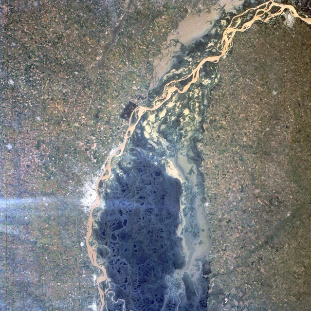 |
| STS056-075-104 Paraná River, Argentina April 1993 The muddy, multibraided channels of the Paraná River are visible as the river flows south past the city of Rosario (population of more than 1 million). The floodplain, much of which appears to be covered by open, sediment-laden water, perhaps experienced some flooding in this section of the Paraná. The dark green area within the confines of the river's floodplain shows the densely vegetated, basically uninhabited swamplands that extend in a swath of unproductive land for 35 miles (60 kilometers) to the western end of the Rio de la Plata. The extensively cultivated field patterns on either side of the river are part of the highly productive agricultural Pampas region, many areas of which are poorly drained, reclaimed swamplands. Rosario, a commercial city approximately 180 miles (290 kilometers) northwest of Buenos Aires, the capital of Argentina, is noted for its transshipping and processing facilities for grains, hay, meat, wool, and sugar. Other smaller urban areas can be seen principally along the west bank of the river, except for Paraná, which lies along the east bank at the northern edge of the photograph. (Refer to STS-056-102-004 for the extensive delta area of the Paraná River near Buenos Aires.) |
| Images: | All Available Images Low-Resolution 197k |
|
| Mission: | STS056 |
|
| Roll - Frame: | 75 - 104 |
|
| Geographical Name: | ARGENTINA |
|
| Features: | RIO PARANA,ROSARIO,AGR. |
|
| Center Lat x Lon: | 32.5S x 60.5W |
|
| Film Exposure: | N | N=Normal exposure, U=Under exposed, O=Over exposed, F=out of Focus |
| Percentage of Cloud Cover-CLDP: | 0 |
|
| Camera:: | HB |
|
| Camera Tilt: | 5 | LO=Low Oblique, HO=High Oblique, NV=Near Vertical |
| Camera Focal Length: | 100 |
|
| Nadir to Photo Center Direction: | SE | The direction from the nadir to the center point, N=North, S=South, E=East, W=West |
| Stereo?: | Y | Y=Yes there is an adjacent picture of the same area, N=No there isn't |
| Orbit Number: | 39 |
|
| Date: | 19930410 | YYYYMMDD |
| Time: | 153513 | GMT HHMMSS |
| Nadir Lat: | 32.4S |
Latitude of suborbital point of spacecraft |
| Nadir Lon: | 60.7W |
Longitude of suborbital point of spacecraft |
| Sun Azimuth: | 11 | Clockwise angle in degrees from north to the sun measured at the nadir point |
| Space Craft Altitude: | 164 | nautical miles |
| Sun Elevation: | 49 | Angle in degrees between the horizon and the sun, measured at the nadir point |
| Land Views: | PLAIN, FOREST |
|
| Water Views: | RIVER, SWAMP, SEDIMENT |
|
| Atmosphere Views: | |
|
| Man Made Views: | AGRICULTURE, AIRPORT, URBAN AREA |
|
| City Views: | |
|
Photo is not associated with any sequences | ||
| NASA Home Page |
JSC Home Page |
JSC Digital Image Collection |
Earth Science & Remote Sensing |
|
This service is provided by the International Space Station program and the JSC Earth Science & Remote Sensing Unit, ARES Division, Exploration Integration Science Directorate.

|