
Geographic Region: OMAN
Feature: OMAN MTS., WAHIBA SANDS
|
Geographic Region: OMAN Feature: OMAN MTS., WAHIBA SANDS |
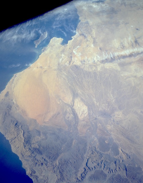 |
| STS056-154-074 Wahibah Sands, Oman April 1993 Wahibah Sands in eastern Oman is a small coastal sand desert that borders the Arabian Sea. The desert demonstrates the results of erosion and deposits caused by running water and wind in this region where the climate has undergone considerable changes. Most sand dunes in Wahibah Sands are north-south oriented, longitudinal dunes. Meandering streams form an extensive pattern as they spread south from the rugged Eastern Hajar Mountains in the north. The Hajars, with major peaks exceeding 7000 feet (2100 meters) above sea level, were formed by the collision of the Arabian and Eurasian plates. Masirah Island is visible off the southeast coast of Oman. |
| Images: | All Available Images Low-Resolution 79k |
|
| Mission: | STS056 |
|
| Roll - Frame: | 154 - 74 |
|
| Geographical Name: | OMAN |
|
| Features: | OMAN MTS., WAHIBA SANDS |
|
| Center Lat x Lon: | 22.5N x 58.0E |
|
| Film Exposure: | N | N=Normal exposure, U=Under exposed, O=Over exposed, F=out of Focus |
| Percentage of Cloud Cover-CLDP: | 10 |
|
| Camera:: | LH |
|
| Camera Tilt: | LO | LO=Low Oblique, HO=High Oblique, NV=Near Vertical |
| Camera Focal Length: | 90 |
|
| Nadir to Photo Center Direction: | The direction from the nadir to the center point, N=North, S=South, E=East, W=West |
|
| Stereo?: | N | Y=Yes there is an adjacent picture of the same area, N=No there isn't |
| Orbit Number: | |
|
| Date: | 199304__ | YYYYMMDD |
| Time: | GMT HHMMSS |
|
| Nadir Lat: | N |
Latitude of suborbital point of spacecraft |
| Nadir Lon: | E |
Longitude of suborbital point of spacecraft |
| Sun Azimuth: | Clockwise angle in degrees from north to the sun measured at the nadir point |
|
| Space Craft Altitude: | nautical miles |
|
| Sun Elevation: | Angle in degrees between the horizon and the sun, measured at the nadir point |
|
| Land Views: | DESERT, DUNE, MOUNTAIN |
|
| Water Views: | |
|
| Atmosphere Views: | |
|
| Man Made Views: | |
|
| City Views: | |
|
Photo is not associated with any sequences | ||
| NASA Home Page |
JSC Home Page |
JSC Digital Image Collection |
Earth Science & Remote Sensing |
|
This service is provided by the International Space Station program and the JSC Earth Science & Remote Sensing Unit, ARES Division, Exploration Integration Science Directorate.

|