Geographic Region: REPUBLIC SOUTH AFRICA
Feature: DRAKENSBERG, C. SEAL
|
Geographic Region: REPUBLIC SOUTH AFRICA Feature: DRAKENSBERG, C. SEAL |
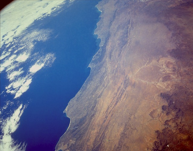 |
| STS056-154-165 The Great Karoo Range and Cape Ranges, South Africa April 1993 This low-oblique, south-southwest-looking photograph reveals the complex landscape of South Africa. The topography of this region is a series of steppes. From the high central plateau (not visible in the photograph) to the Great Escarpment, at an altitude of 7000 feet (2135 meters), that appears along the north side of the photograph, the terrain descends into a vast semiarid plateau called the Great Karoo (orange area). This hot, arid plateau extends east-west 300 miles (500 kilometers) and averages 2000 to 4000 feet (600 to 1200 meters) above sea level. Descending further across smaller escarpments and plains, the steppes reach the mountains of the forested Cape Ranges (dark green) and, finally, the coast. Where irrigated, the Great Karoo is very fertile and supports extensive livestock grazing and the growing of citrus fruit and grains. The Great Karoo is covered mostly by succulent plants that survive the heat and aridity by conserving moisture or having life cycles geared to the occasional violent storms that pass over the region. Three pronounced capes lie along the coast--from east to west are Cape St. Francis, Cape Seal, and Cape St. Blaize located near the small port city of Mosselbaai. |
| Images: | All Available Images Low-Resolution 95k |
|
| Mission: | STS056 |
|
| Roll - Frame: | 154 - 165 |
|
| Geographical Name: | REPUBLIC SOUTH AFRICA |
|
| Features: | DRAKENSBERG, C. SEAL |
|
| Center Lat x Lon: | 34S x 24.0E |
|
| Film Exposure: | N | N=Normal exposure, U=Under exposed, O=Over exposed, F=out of Focus |
| Percentage of Cloud Cover-CLDP: | 15 |
|
| Camera:: | LH |
|
| Camera Tilt: | LO | LO=Low Oblique, HO=High Oblique, NV=Near Vertical |
| Camera Focal Length: | 90 |
|
| Nadir to Photo Center Direction: | The direction from the nadir to the center point, N=North, S=South, E=East, W=West |
|
| Stereo?: | N | Y=Yes there is an adjacent picture of the same area, N=No there isn't |
| Orbit Number: | |
|
| Date: | 199304__ | YYYYMMDD |
| Time: | GMT HHMMSS |
|
| Nadir Lat: | N |
Latitude of suborbital point of spacecraft |
| Nadir Lon: | E |
Longitude of suborbital point of spacecraft |
| Sun Azimuth: | Clockwise angle in degrees from north to the sun measured at the nadir point |
|
| Space Craft Altitude: | nautical miles |
|
| Sun Elevation: | Angle in degrees between the horizon and the sun, measured at the nadir point |
|
| Land Views: | MOUNTAIN, HILL, PLATEAU, DESERT, COAST |
|
| Water Views: | RIVER, RESERVOIR |
|
| Atmosphere Views: | |
|
| Man Made Views: | |
|
| City Views: | |
|
Photo is not associated with any sequences | ||
| NASA Home Page |
JSC Home Page |
JSC Digital Image Collection |
Earth Science & Remote Sensing |
|
This service is provided by the International Space Station program and the JSC Earth Science & Remote Sensing Unit, ARES Division, Exploration Integration Science Directorate.

|