
Geographic Region: AUSTRALIA-V
Feature: PAN,VIEW E,MURRAY R,COAST
|
Geographic Region: AUSTRALIA-V Feature: PAN,VIEW E,MURRAY R,COAST |
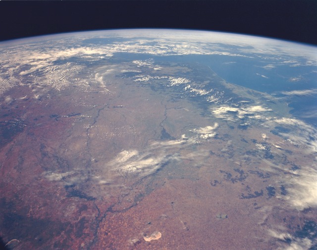 |
| STS056-153-70 Murray River Basin, New South Wales and Victoria, Australia April 1993 In this high-oblique, south-southeast-looking photograph, the Murray River Basin and the southeast coastline of Australia are apparent. The dark green forested areas, inland from the coast and partially obscured by clouds, are the Australian Alps. The principal river of Australia, the Murray, is 1609 miles (2589 kilometers) long. Near the Murray's source in the Australian Alps is the Hume Reservoir (barely visible in the photograph), which helps regulate the river's flow and provides water for extensive pasturelands and areas where citrus fruits, vegetables, and vine products are grown. Extensive agricultural field patterns are scattered throughout the region. Near the center of the photograph is a large, green, delta-shaped region, which is the remnants of an old Murray River delta formed millions of years ago when the climate was much wetter. Northwest of the delta lies Lake Tyrrel, an almost dry lakebed. Northeast of Lake Tyrrel the waters of the Murrumbidgee River enter the Murray River. |
| Images: | All Available Images Low-Resolution 91k |
|
| Mission: | STS056 |
|
| Roll - Frame: | 153 - 70 |
|
| Geographical Name: | AUSTRALIA-V |
|
| Features: | PAN,VIEW E,MURRAY R,COAST |
|
| Center Lat x Lon: | N x E |
|
| Film Exposure: | N | N=Normal exposure, U=Under exposed, O=Over exposed, F=out of Focus |
| Percentage of Cloud Cover-CLDP: | 50 |
|
| Camera:: | LH |
|
| Camera Tilt: | HO | LO=Low Oblique, HO=High Oblique, NV=Near Vertical |
| Camera Focal Length: | 90 |
|
| Nadir to Photo Center Direction: | The direction from the nadir to the center point, N=North, S=South, E=East, W=West |
|
| Stereo?: | Y | Y=Yes there is an adjacent picture of the same area, N=No there isn't |
| Orbit Number: | |
|
| Date: | 199304__ | YYYYMMDD |
| Time: | GMT HHMMSS |
|
| Nadir Lat: | N |
Latitude of suborbital point of spacecraft |
| Nadir Lon: | E |
Longitude of suborbital point of spacecraft |
| Sun Azimuth: | Clockwise angle in degrees from north to the sun measured at the nadir point |
|
| Space Craft Altitude: | nautical miles |
|
| Sun Elevation: | Angle in degrees between the horizon and the sun, measured at the nadir point |
|
| Land Views: | BASIN, VALLEY, HILL |
|
| Water Views: | RIVER, RESERVOIR |
|
| Atmosphere Views: | |
|
| Man Made Views: | AGRICULTURE |
|
| City Views: | |
|
Photo is not associated with any sequences | ||
| NASA Home Page |
JSC Home Page |
JSC Digital Image Collection |
Earth Science & Remote Sensing |
|
This service is provided by the International Space Station program and the JSC Earth Science & Remote Sensing Unit, ARES Division, Exploration Integration Science Directorate.

|