
Geographic Region: AUSTRALIA-WA
Feature: COAST,BONAPARTE ISLANDS
|
Geographic Region: AUSTRALIA-WA Feature: COAST,BONAPARTE ISLANDS |
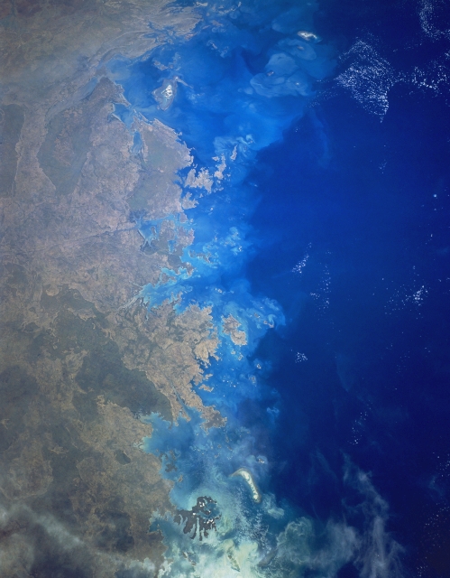 |
| STS056-153-053 Bonaparte Archipelago, Western Australia, Australia April 1993 The Bonaparte Archipelago stretches along the north coast of the Kimberley Plateau in Western Australia. This particular image extends from Vansittart Bay (small area of sunglint at bottom center) to Collier Bay (upper middle). The shallow coastal waters of the continental shelf are light blue in color and include reefs and shoals. The deeper waters of the Indian Ocean are dark blue in color. The colors of the land reflect differences in elevation and the associated vegetation. The darkest terrain is more elevated, usually more than 1000 feet (305 meters) above sea level. |
| Images: | All Available Images Low-Resolution 240k |
|
| Mission: | STS056 |
|
| Roll - Frame: | 153 - 53 |
|
| Geographical Name: | AUSTRALIA-WA |
|
| Features: | COAST,BONAPARTE ISLANDS |
|
| Center Lat x Lon: | 14.5S x 125.0E |
|
| Film Exposure: | N | N=Normal exposure, U=Under exposed, O=Over exposed, F=out of Focus |
| Percentage of Cloud Cover-CLDP: | 0 |
|
| Camera:: | LH |
|
| Camera Tilt: | LO | LO=Low Oblique, HO=High Oblique, NV=Near Vertical |
| Camera Focal Length: | 90 |
|
| Nadir to Photo Center Direction: | The direction from the nadir to the center point, N=North, S=South, E=East, W=West |
|
| Stereo?: | Y | Y=Yes there is an adjacent picture of the same area, N=No there isn't |
| Orbit Number: | |
|
| Date: | 199304__ | YYYYMMDD |
| Time: | GMT HHMMSS |
|
| Nadir Lat: | N |
Latitude of suborbital point of spacecraft |
| Nadir Lon: | E |
Longitude of suborbital point of spacecraft |
| Sun Azimuth: | Clockwise angle in degrees from north to the sun measured at the nadir point |
|
| Space Craft Altitude: | nautical miles |
|
| Sun Elevation: | Angle in degrees between the horizon and the sun, measured at the nadir point |
|
| Land Views: | ISLAND, COAST, PENINSULA |
|
| Water Views: | BAY, STRAIT, GULF |
|
| Atmosphere Views: | |
|
| Man Made Views: | |
|
| City Views: | |
|
Photo is not associated with any sequences | ||
| NASA Home Page |
JSC Home Page |
JSC Digital Image Collection |
Earth Science & Remote Sensing |
|
This service is provided by the International Space Station program and the JSC Earth Science & Remote Sensing Unit, ARES Division, Exploration Integration Science Directorate.

|