Geographic Region: MOROCCO
Feature: COAST,CASABLANCA,INTERIOR
|
Geographic Region: MOROCCO Feature: COAST,CASABLANCA,INTERIOR |
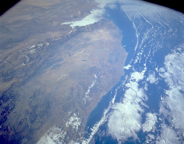 |
| STS056-153-182 Coastal Plains, Morocco April 1993 Although one-third of Morocco is mountainous, this photograph shows the country's west-central coastal plains. Casablanca, the largest city, chief port, and major manufacturing center of the country, is visible along the coast near the center of the photograph. The topography east of Casablanca is dissected plateau and hilly terrain. Annual rainfall seldom exceeds 12 inches (30 centimeters) for any part of this region, although rainfall amounts increase slightly from the west coast toward the Atlas Mountains. These mountains extend across the entire southeastern frontier of Morocco and form a major physical barrier for ground transportation. Several dark green areas show the larger concentrations of agricultural activities. A small section of the northeast-southwest trending Atlas Mountains can be seen as a well-defined line of snow-capped mountains (southeast quadrant of the photograph), with remaining snow found only in elevations exceeding 9000 feet (2700 meters). Several peaks within the Atlas range exceed 12 000 feet (3600 meters) above sea level. |
| Images: | All Available Images Low-Resolution 102k |
|
| Mission: | STS056 |
|
| Roll - Frame: | 153 - 182 |
|
| Geographical Name: | MOROCCO |
|
| Features: | COAST,CASABLANCA,INTERIOR |
|
| Center Lat x Lon: | 33.0N x 7W |
|
| Film Exposure: | N | N=Normal exposure, U=Under exposed, O=Over exposed, F=out of Focus |
| Percentage of Cloud Cover-CLDP: | 40 |
|
| Camera:: | LH |
|
| Camera Tilt: | 36 | LO=Low Oblique, HO=High Oblique, NV=Near Vertical |
| Camera Focal Length: | 90 |
|
| Nadir to Photo Center Direction: | S | The direction from the nadir to the center point, N=North, S=South, E=East, W=West |
| Stereo?: | Y | Y=Yes there is an adjacent picture of the same area, N=No there isn't |
| Orbit Number: | 66 |
|
| Date: | 19930412 | YYYYMMDD |
| Time: | 075601 | GMT HHMMSS |
| Nadir Lat: | 34.8N |
Latitude of suborbital point of spacecraft |
| Nadir Lon: | 6.2W |
Longitude of suborbital point of spacecraft |
| Sun Azimuth: | 96 | Clockwise angle in degrees from north to the sun measured at the nadir point |
| Space Craft Altitude: | 160 | nautical miles |
| Sun Elevation: | 23 | Angle in degrees between the horizon and the sun, measured at the nadir point |
| Land Views: | MOUNTAIN, PLAIN, COAST, FAULT |
|
| Water Views: | RIVER |
|
| Atmosphere Views: | |
|
| Man Made Views: | AGRICULTURE, URBAN AREA |
|
| City Views: | |
|
Photo is not associated with any sequences | ||
| NASA Home Page |
JSC Home Page |
JSC Digital Image Collection |
Earth Science & Remote Sensing |
|
This service is provided by the International Space Station program and the JSC Earth Science & Remote Sensing Unit, ARES Division, Exploration Integration Science Directorate.

|