Geographic Region: CHINA
Feature: KARAKORAM RA,GLACIERS
|
Geographic Region: CHINA Feature: KARAKORAM RA,GLACIERS |
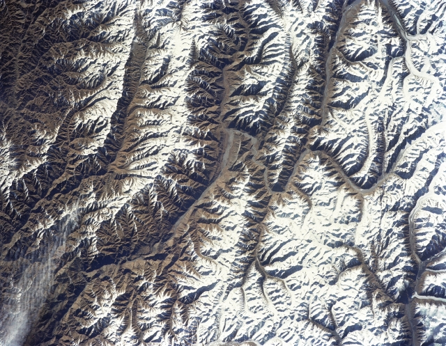 |
| STS056-152-033 Karakorum Mountains, China April 1993 The Karakorum Mountain Range is a rugged scene of glaciated mountains and U-shaped valleys that are found in extreme western China and northeast Pakistan (upper right quadrant). The snow capped (white) peaks and mountain ridges, where many peaks exceed 20000 feet (6096 meters) above sea level, present a dramatic color contrast with the broad, glaciated valleys (darker, linear feature) where the valley floors average around 13000 feet (3962 meters) above sea level. Several valley glaciers are visible along the southern (top) edge of the image. The deeply weathered, angular-looking mountain structure shows the results of ice and water erosion on this hostile and barren environment. Some of the valleys have mountain passes that allow ground movement through the mountains. A small section of STS56-152-038 overlaps with the southeastern (upper left corner) part of this image. STS-56 Earth observation shows of some of the highest mountain peaks in the world taken from Discovery, Orbiter Vehicle (OV) 103, as it passed over India and China. The top of the view shows one of the snow and ice-covered massifs in the great Karakorum Range of north India. A star-shaped peak at top left reaches 23,850 feet. Glaciers can be seen in valleys at these high elevations. The international border between India to the south (top) and China (bottom) snakes left to right along a river near the top of the scene, then veers into the muntains at top left. Larger valleys, despite their elevation (all in excess of 14,000 feet), are occupied by transport routes joining points in India, China and the southern republics of the CIS. The ancient Silk Route between China and the Middle East lies not far to the north (outside the bottom of the frame). |
| Images: | All Available Images Low-Resolution 355k |
|
| Mission: | STS056 |
|
| Roll - Frame: | 152 - 33 |
|
| Geographical Name: | CHINA |
|
| Features: | KARAKORAM RA,GLACIERS |
|
| Center Lat x Lon: | 36.0N x 76.0E |
|
| Film Exposure: | N | N=Normal exposure, U=Under exposed, O=Over exposed, F=out of Focus |
| Percentage of Cloud Cover-CLDP: | 5 |
|
| Camera:: | LH |
|
| Camera Tilt: | 22 | LO=Low Oblique, HO=High Oblique, NV=Near Vertical |
| Camera Focal Length: | 250 |
|
| Nadir to Photo Center Direction: | SE | The direction from the nadir to the center point, N=North, S=South, E=East, W=West |
| Stereo?: | Y | Y=Yes there is an adjacent picture of the same area, N=No there isn't |
| Orbit Number: | 31 |
|
| Date: | 19930410 | YYYYMMDD |
| Time: | 031044 | GMT HHMMSS |
| Nadir Lat: | 36.7N |
Latitude of suborbital point of spacecraft |
| Nadir Lon: | 75.2E |
Longitude of suborbital point of spacecraft |
| Sun Azimuth: | 104 | Clockwise angle in degrees from north to the sun measured at the nadir point |
| Space Craft Altitude: | 162 | nautical miles |
| Sun Elevation: | 31 | Angle in degrees between the horizon and the sun, measured at the nadir point |
| Land Views: | MOUNTAIN, VALLEY, FAULT |
|
| Water Views: | |
|
| Atmosphere Views: | |
|
| Man Made Views: | |
|
| City Views: | |
|
Photo is not associated with any sequences | ||
| NASA Home Page |
JSC Home Page |
JSC Digital Image Collection |
Earth Science & Remote Sensing |
|
This service is provided by the International Space Station program and the JSC Earth Science & Remote Sensing Unit, ARES Division, Exploration Integration Science Directorate.

|