
Geographic Region: CHILE
Feature: ATACAMA DES,ALTIPLANO
|
Geographic Region: CHILE Feature: ATACAMA DES,ALTIPLANO |
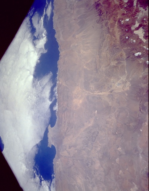 |
| STS056-152-249 Atacama Desert, Chile April 1993 This low-oblique, north-looking photograph features the Atacama Desert, one of the world's driest regions. A virtually rainless plateau, the Atacama, the average width of which is 90 miles (145 kilometers), extends 600 miles (965 kilometers) south from the border of Peru to the area near Copiapó, Chile (not in photograph). The Pacific coastal range, with an average elevation of 2500 feet (765 meters), lies west of the desert (visible in the photograph). The Cordillera Domeyko, a range of foothills of the Andes Mountains, lies east (snow-covered peaks are visible to the northeast). The Atacama, whose average elevation is 2000 feet (610 meters), comprises a series of salt basins (salars) interspersed with broad tracts of sand and lava. Although many parts of the desert plateau receive no rain for decades, a few summer showers may fall on the foothills of the Andes. Except for a few oases or irrigation system locations, the desert has no vegetation; however, the desert has the world's largest natural supply of sodium nitrate, which was mined on a large scale until the early 1940s, and rich deposits of copper and other minerals. The most famous copper mine is in Chuquicamata, near the Andes foothills (barely visible in the photograph). The Mejillones Peninsula juts westward into the Pacific Ocean. The port city of Antofagasta (barely visible in the photograph) on the peninsula's southwest coast is a major shipping port for sodium nitrate, copper, and other minerals. The Atacama economy is declining as reserves of these minerals are depleted and the desert expands into once arable land. |
| Images: | All Available Images Low-Resolution 76k |
|
| Mission: | STS056 |
|
| Roll - Frame: | 152 - 249 |
|
| Geographical Name: | CHILE |
|
| Features: | ATACAMA DES,ALTIPLANO |
|
| Center Lat x Lon: | 22.5S x 69W |
|
| Film Exposure: | N | N=Normal exposure, U=Under exposed, O=Over exposed, F=out of Focus |
| Percentage of Cloud Cover-CLDP: | 20 |
|
| Camera:: | LH |
|
| Camera Tilt: | 11 | LO=Low Oblique, HO=High Oblique, NV=Near Vertical |
| Camera Focal Length: | 90 |
|
| Nadir to Photo Center Direction: | W | The direction from the nadir to the center point, N=North, S=South, E=East, W=West |
| Stereo?: | Y | Y=Yes there is an adjacent picture of the same area, N=No there isn't |
| Orbit Number: | 39 |
|
| Date: | 19930410 | YYYYMMDD |
| Time: | 153203 | GMT HHMMSS |
| Nadir Lat: | 22.6S |
Latitude of suborbital point of spacecraft |
| Nadir Lon: | 68.5W |
Longitude of suborbital point of spacecraft |
| Sun Azimuth: | 29 | Clockwise angle in degrees from north to the sun measured at the nadir point |
| Space Craft Altitude: | 162 | nautical miles |
| Sun Elevation: | 56 | Angle in degrees between the horizon and the sun, measured at the nadir point |
| Land Views: | DESERT, PLATEAU, HILL |
|
| Water Views: | |
|
| Atmosphere Views: | |
|
| Man Made Views: | |
|
| City Views: | |
|
Photo is not associated with any sequences | ||
| NASA Home Page |
JSC Home Page |
JSC Digital Image Collection |
Earth Science & Remote Sensing |
|
This service is provided by the International Space Station program and the JSC Earth Science & Remote Sensing Unit, ARES Division, Exploration Integration Science Directorate.

|