 Photo #: STS056-151-253 Date: Apr. 1993
Geographic Region: REPUBLIC SOUTH AFRICA
Feature: DRAKENSBERG

 Photo #: STS056-151-253 Date: Apr. 1993 Photo #: STS056-151-253 Date: Apr. 1993Geographic Region: REPUBLIC SOUTH AFRICA Feature: DRAKENSBERG |
 |
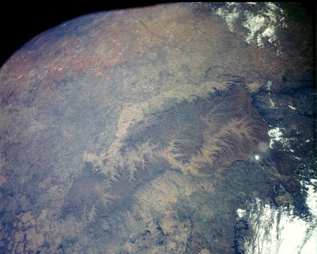
| STS056-151-253 Drakensberg Range, Lesotho April 1993 This low-oblique, northwest-looking photograph shows the entire landlocked country of Lesotho, which is completely surrounded by South Africa. Lesotho consists mainly of a high mountainous plateau, with the Drakensberg Range and its steep escarpment to the east forming the east and southeast border; along the western border, the elevation gradually becomes lower as the landscape grades into a lower belt of foothills and lowlands. The Orange River (recognizable by its serpentine pattern almost in the center of the photograph) originates in the basaltic lava in the eastern third of Lesotho and exits the country through the sandstone rocks south of Mohale's Hoek. The highest mountain peak in southern Africa, Thabana Ntlenyana at 11 425 feet (3481 meters), is near the easternmost edge of Lesotho in the Drakensberg Range. The northeast-southwest-trending Maloti Mountains, in northwestern Lesotho, have several peaks that exceed 10 000 feet (3048 meters). The lighter colored strip of land northwest of the Maloti Mountains is the severely eroded and overgrazed lowland area of Lesotho. Although only one-eight of the land is suitable for farming because of steep slopes and thin soils, the vast majority of residents is engaged in agriculture. Toward the northwest lies part of South Africa's Orange Free State, dotted with many highly reflective salt pans or dry lakebeds. |
| Images: | All Available Images Low-Resolution 124k |
|
| Mission: | STS056 |
|
| Roll - Frame: | 151 - 253 |
|
| Geographical Name: | REPUBLIC SOUTH AFRICA |
|
| Features: | DRAKENSBERG |
|
| Center Lat x Lon: | 31S x 28.0E |
|
| Film Exposure: | N | N=Normal exposure, U=Under exposed, O=Over exposed, F=out of Focus |
| Percentage of Cloud Cover-CLDP: | 10 |
|
| Camera:: | LH |
|
| Camera Tilt: | 31 | LO=Low Oblique, HO=High Oblique, NV=Near Vertical |
| Camera Focal Length: | 90 |
|
| Nadir to Photo Center Direction: | W | The direction from the nadir to the center point, N=North, S=South, E=East, W=West |
| Stereo?: | Y | Y=Yes there is an adjacent picture of the same area, N=No there isn't |
| Orbit Number: | 35 |
|
| Date: | 19930410 | YYYYMMDD |
| Time: | 093303 | GMT HHMMSS |
| Nadir Lat: | 30.7S |
Latitude of suborbital point of spacecraft |
| Nadir Lon: | 29.6E |
Longitude of suborbital point of spacecraft |
| Sun Azimuth: | 12 | Clockwise angle in degrees from north to the sun measured at the nadir point |
| Space Craft Altitude: | 164 | nautical miles |
| Sun Elevation: | 51 | Angle in degrees between the horizon and the sun, measured at the nadir point |
| Land Views: | MOUNTAIN, PLATEAU, ESCARPMENT |
|
| Water Views: | RIVER, LAKE |
|
| Atmosphere Views: | |
|
| Man Made Views: | AGRICULTURE |
|
| City Views: | |
|
Photo is not associated with any sequences | ||
| NASA Home Page |
JSC Home Page |
JSC Digital Image Collection |
Earth Science & Remote Sensing |
|
|