
Geographic Region: GREECE
Feature: THESSALONIKI,AEGEAN SEA
|
Geographic Region: GREECE Feature: THESSALONIKI,AEGEAN SEA |
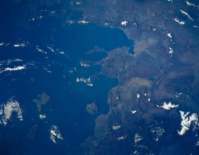 |
| STS056-151-163 Rhodope Mountains, Struma River, Greece/Bulgaria April 1993 Covering the left portion of the image, the rugged, snow-capped Rhodope Mountains can be seen in this southeast-looking view. The Rhodope Mountains stretch northwest to southeast along the Bulgarian and Greek border 200 miles (320 km). They are forested and have very few passes. Just to the right (west) of the center of the image, the Struma River Valley is visible. The Struma River rises in the mountains of western Bulgaria (not visible in the image) and flows generally southeast for 216 miles (348 km) before emptying in the Strymonic Gulf (upper right), an arm of the Aegean Sea. Numerous canals have been constructed in the northern Struma River Valley (south of Kerkinis Lake) to support agriculture. To the right (west) of the river valley are the Pangaion Mountains, a low range of mountains that in ancient times were known for their gold and silver mines. West of the Pangaion Mountains is Voevi Lake. |
| Images: | All Available Images Low-Resolution 249k |
|
| Mission: | STS056 |
|
| Roll - Frame: | 151 - 163 |
|
| Geographical Name: | GREECE |
|
| Features: | THESSALONIKI,AEGEAN SEA |
|
| Center Lat x Lon: | 40.0N x 24.0E |
|
| Film Exposure: | N | N=Normal exposure, U=Under exposed, O=Over exposed, F=out of Focus |
| Percentage of Cloud Cover-CLDP: | 5 |
|
| Camera:: | LH |
|
| Camera Tilt: | LO | LO=Low Oblique, HO=High Oblique, NV=Near Vertical |
| Camera Focal Length: | 90 |
|
| Nadir to Photo Center Direction: | The direction from the nadir to the center point, N=North, S=South, E=East, W=West |
|
| Stereo?: | Y | Y=Yes there is an adjacent picture of the same area, N=No there isn't |
| Orbit Number: | |
|
| Date: | 199304__ | YYYYMMDD |
| Time: | GMT HHMMSS |
|
| Nadir Lat: | N |
Latitude of suborbital point of spacecraft |
| Nadir Lon: | E |
Longitude of suborbital point of spacecraft |
| Sun Azimuth: | Clockwise angle in degrees from north to the sun measured at the nadir point |
|
| Space Craft Altitude: | nautical miles |
|
| Sun Elevation: | Angle in degrees between the horizon and the sun, measured at the nadir point |
|
| Land Views: | MOUNTAIN, VALLEY, FAULT, FOREST |
|
| Water Views: | RIVER, LAKE, GULF |
|
| Atmosphere Views: | |
|
| Man Made Views: | |
|
| City Views: | |
|
Photo is not associated with any sequences | ||
| NASA Home Page |
JSC Home Page |
JSC Digital Image Collection |
Earth Science & Remote Sensing |
|
This service is provided by the International Space Station program and the JSC Earth Science & Remote Sensing Unit, ARES Division, Exploration Integration Science Directorate.

|