
Geographic Region: USA-TEXAS
Feature: LAREDO-NUEVA LAREDO
|
Geographic Region: USA-TEXAS Feature: LAREDO-NUEVA LAREDO |
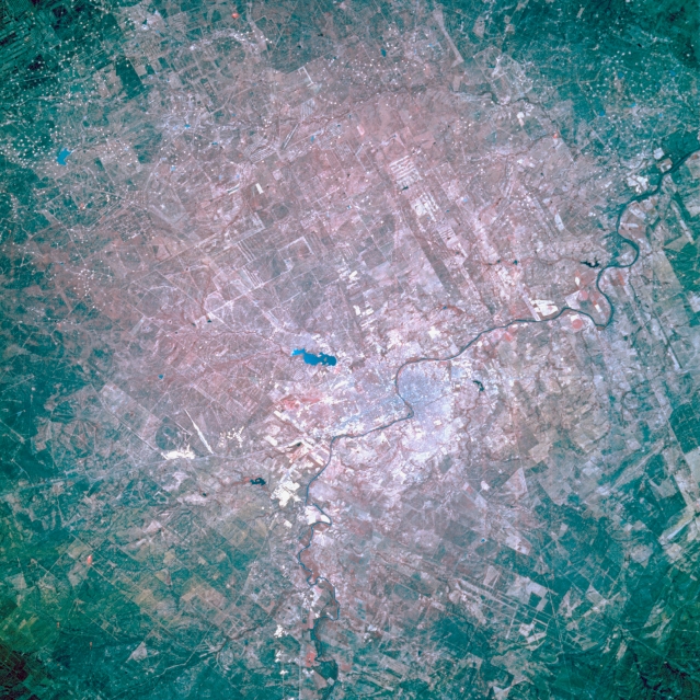 |
| STS056-109-030 Laredo, Texas, U.S.A. April 1993 The border city of Laredo is visible on the east side of the Rio Grande, with Nuevo Laredo, its Mexican counterpart, on the west. Lake Casa Blanca lies northeast of Laredo. The color infrared film does not produce a meaningful rendering of the sandstone and claystone beds that underlie this region of south Texas. White dots (bottom third) show the distribution and density of gas and oil fields. The semiarid climate, receiving less than 20 inches (50 centimeters) of precipitation per year, combined with a very high rate of evaporation promotes the growth of cactus and thornbrush. |
| Images: | All Available Images Low-Resolution 408k |
|
| Mission: | STS056 |
|
| Roll - Frame: | 109 - 30 |
|
| Geographical Name: | USA-TEXAS |
|
| Features: | LAREDO-NUEVA LAREDO |
|
| Center Lat x Lon: | 27.5N x 99.5W |
|
| Film Exposure: | N | N=Normal exposure, U=Under exposed, O=Over exposed, F=out of Focus |
| Percentage of Cloud Cover-CLDP: | 0 |
|
| Camera:: | HB |
|
| Camera Tilt: | 14 | LO=Low Oblique, HO=High Oblique, NV=Near Vertical |
| Camera Focal Length: | 250 |
|
| Nadir to Photo Center Direction: | SE | The direction from the nadir to the center point, N=North, S=South, E=East, W=West |
| Stereo?: | N | Y=Yes there is an adjacent picture of the same area, N=No there isn't |
| Orbit Number: | 39 |
|
| Date: | 19930410 | YYYYMMDD |
| Time: | 151646 | GMT HHMMSS |
| Nadir Lat: | 27.8N |
Latitude of suborbital point of spacecraft |
| Nadir Lon: | 100.1W |
Longitude of suborbital point of spacecraft |
| Sun Azimuth: | 102 | Clockwise angle in degrees from north to the sun measured at the nadir point |
| Space Craft Altitude: | 161 | nautical miles |
| Sun Elevation: | 38 | Angle in degrees between the horizon and the sun, measured at the nadir point |
| Land Views: | RANGE |
|
| Water Views: | RIVER |
|
| Atmosphere Views: | |
|
| Man Made Views: | URBAN AREA, DRILLING |
|
| City Views: | |
|
Photo is not associated with any sequences | ||
| NASA Home Page |
JSC Home Page |
JSC Digital Image Collection |
Earth Science & Remote Sensing |
|
This service is provided by the International Space Station program and the JSC Earth Science & Remote Sensing Unit, ARES Division, Exploration Integration Science Directorate.

|