
Geographic Region: USA-TEXAS
Feature: AMISTAD RESERVOIR
|
Geographic Region: USA-TEXAS Feature: AMISTAD RESERVOIR |
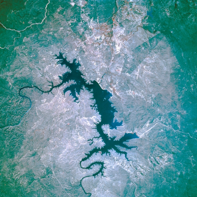 |
| STS056-109-27 International Amistad Reservoir, Texas, U.S.A. April 1993 The color infrared film in this photograph is best used to map the land-water boundary around International Amistad Reservoir, a dammed section of the Rio Grande just northwest of Del Rio, whose infrastructure is not discernible. The Rio Grande enters the reservoir from the northwest, and Devils River flows into the northeast side. The dam is the thin, white feature south of the reservoir. |
| Images: | All Available Images Low-Resolution 403k |
|
| Mission: | STS056 |
|
| Roll - Frame: | 109 - 27 |
|
| Geographical Name: | USA-TEXAS |
|
| Features: | AMISTAD RESERVOIR |
|
| Center Lat x Lon: | 29.5N x 101W |
|
| Film Exposure: | N | N=Normal exposure, U=Under exposed, O=Over exposed, F=out of Focus |
| Percentage of Cloud Cover-CLDP: | 0 |
|
| Camera:: | HB |
|
| Camera Tilt: | 13 | LO=Low Oblique, HO=High Oblique, NV=Near Vertical |
| Camera Focal Length: | 250 |
|
| Nadir to Photo Center Direction: | E | The direction from the nadir to the center point, N=North, S=South, E=East, W=West |
| Stereo?: | N | Y=Yes there is an adjacent picture of the same area, N=No there isn't |
| Orbit Number: | 39 |
|
| Date: | 19930410 | YYYYMMDD |
| Time: | 151612 | GMT HHMMSS |
| Nadir Lat: | 29.5N |
Latitude of suborbital point of spacecraft |
| Nadir Lon: | 101.6W |
Longitude of suborbital point of spacecraft |
| Sun Azimuth: | 102 | Clockwise angle in degrees from north to the sun measured at the nadir point |
| Space Craft Altitude: | 161 | nautical miles |
| Sun Elevation: | 36 | Angle in degrees between the horizon and the sun, measured at the nadir point |
| Land Views: | RANGE, HILL |
|
| Water Views: | RIVER, RESERVOIR |
|
| Atmosphere Views: | |
|
| Man Made Views: | |
|
| City Views: | |
|
Photo is not associated with any sequences | ||
| NASA Home Page |
JSC Home Page |
JSC Digital Image Collection |
Earth Science & Remote Sensing |
|
This service is provided by the International Space Station program and the JSC Earth Science & Remote Sensing Unit, ARES Division, Exploration Integration Science Directorate.

|