
Geographic Region: USA-TEXAS
Feature: FT. STOCKTON, TEST TRACK
|
Geographic Region: USA-TEXAS Feature: FT. STOCKTON, TEST TRACK |
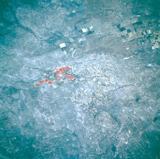 |
| STS056-109-026 Fort Stockton, Texas, U.S.A. April 1993 While this color infrared photograph shows almost none of the infrastructure of Fort Stockton, the convergence of railroads and highways is discernible. The color infrared film accentuates the reds (green vegetation) of the circular and rectangular cultivated fields southwest of Fort Stockton. Also apparent are a small, intermittently flowing drainage basin with its short tributary streams north of the irrigated fields and an oval track northwest of the fields and north of Interstate Highway 10. |
| Images: | All Available Images Low-Resolution 383k |
|
| Mission: | STS056 |
|
| Roll - Frame: | 109 - 26 |
|
| Geographical Name: | USA-TEXAS |
|
| Features: | FT. STOCKTON, TEST TRACK |
|
| Center Lat x Lon: | 31.0N x 103W |
|
| Film Exposure: | N | N=Normal exposure, U=Under exposed, O=Over exposed, F=out of Focus |
| Percentage of Cloud Cover-CLDP: | 0 |
|
| Camera:: | HB |
|
| Camera Tilt: | 13 | LO=Low Oblique, HO=High Oblique, NV=Near Vertical |
| Camera Focal Length: | 250 |
|
| Nadir to Photo Center Direction: | NW | The direction from the nadir to the center point, N=North, S=South, E=East, W=West |
| Stereo?: | N | Y=Yes there is an adjacent picture of the same area, N=No there isn't |
| Orbit Number: | 39 |
|
| Date: | 19930410 | YYYYMMDD |
| Time: | 151552 | GMT HHMMSS |
| Nadir Lat: | 30.6N |
Latitude of suborbital point of spacecraft |
| Nadir Lon: | 102.5W |
Longitude of suborbital point of spacecraft |
| Sun Azimuth: | 102 | Clockwise angle in degrees from north to the sun measured at the nadir point |
| Space Craft Altitude: | 162 | nautical miles |
| Sun Elevation: | 35 | Angle in degrees between the horizon and the sun, measured at the nadir point |
| Land Views: | HILL, DESERT |
|
| Water Views: | |
|
| Atmosphere Views: | |
|
| Man Made Views: | |
|
| City Views: | |
|
Photo is not associated with any sequences | ||
| NASA Home Page |
JSC Home Page |
JSC Digital Image Collection |
Earth Science & Remote Sensing |
|
This service is provided by the International Space Station program and the JSC Earth Science & Remote Sensing Unit, ARES Division, Exploration Integration Science Directorate.

|