
Geographic Region: USA-NEW MEXICO
Feature: PECOS R., NEAR LOVING
|
Geographic Region: USA-NEW MEXICO Feature: PECOS R., NEAR LOVING |
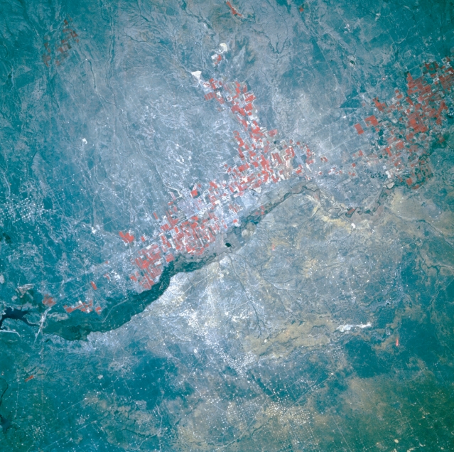 |
| STS056-109-023 Pecos River Valley, New Mexico, U.S.A. April 1993 A small segment of the south-flowing Pecos River appears in this color infrared photograph of southeastern New Mexico. Artesia (barely discernible in the center of the photograph) is located in this semiarid region that receives an average of 15 inches (38 centimeters) of precipitation each year. Major economic activities include farming and fossil fuel extraction. The clusters of small white dots denote oil- and gas-producing fields. The reddish, rectangular field patterns (red colors reveal green vegetation) indicate irrigated agriculture along the Pecos River. When water is not available from the river, farmers use artesian well water that flows under pressure through aquifers from the eastern slopes of the mountains west of this region. |
| Images: | All Available Images Low-Resolution 391k |
|
| Mission: | STS056 |
|
| Roll - Frame: | 109 - 23 |
|
| Geographical Name: | USA-NEW MEXICO |
|
| Features: | PECOS R., NEAR LOVING |
|
| Center Lat x Lon: | 32.0N x 104W |
|
| Film Exposure: | N | N=Normal exposure, U=Under exposed, O=Over exposed, F=out of Focus |
| Percentage of Cloud Cover-CLDP: | 0 |
|
| Camera:: | HB |
|
| Camera Tilt: | 21 | LO=Low Oblique, HO=High Oblique, NV=Near Vertical |
| Camera Focal Length: | 250 |
|
| Nadir to Photo Center Direction: | SE | The direction from the nadir to the center point, N=North, S=South, E=East, W=West |
| Stereo?: | N | Y=Yes there is an adjacent picture of the same area, N=No there isn't |
| Orbit Number: | 39 |
|
| Date: | 19930410 | YYYYMMDD |
| Time: | 151507 | GMT HHMMSS |
| Nadir Lat: | 32.9N |
Latitude of suborbital point of spacecraft |
| Nadir Lon: | 104.5W |
Longitude of suborbital point of spacecraft |
| Sun Azimuth: | 102 | Clockwise angle in degrees from north to the sun measured at the nadir point |
| Space Craft Altitude: | 162 | nautical miles |
| Sun Elevation: | 33 | Angle in degrees between the horizon and the sun, measured at the nadir point |
| Land Views: | VALLEY |
|
| Water Views: | RIVER |
|
| Atmosphere Views: | |
|
| Man Made Views: | AGRICULTURE, DRILLING |
|
| City Views: | |
|
Photo is not associated with any sequences | ||
| NASA Home Page |
JSC Home Page |
JSC Digital Image Collection |
Earth Science & Remote Sensing |
|
This service is provided by the International Space Station program and the JSC Earth Science & Remote Sensing Unit, ARES Division, Exploration Integration Science Directorate.

|