
Geographic Region: AUSTRALIA-T
Feature: FLINDERS I., C. BARREN I.
|
Geographic Region: AUSTRALIA-T Feature: FLINDERS I., C. BARREN I. |
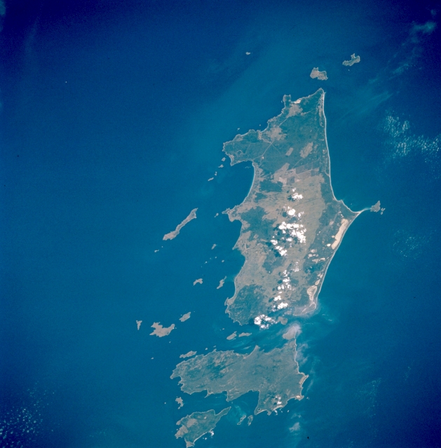 |
| STS056-104-088 Flinders Island, Tasmania, Australia April 1993 Flinders Island, the largest of the three large islands (Cape Barren is second in size and then Clarke Island) in this view, is located off the northeast tip of Tasmania in the Furneaux Group of islands. Fishing, grazing, and tourism are the leading economic activities of Flinders Island. Geologically the low granite mountainous terrain on these islands, with elevations ranging from less than 1000 feet (305 meters) to slightly over 2500 feet (760 meters) above sea level, are a southern extension of the mountains in southeastern Australia (eastern Victoria). The highest peak (2550 feet--780 meters) on Flinders Island is located in Strzelecki National Park at the southwestern end of the island (dark, vegetated feature). Mountainous terrain can be identified on the picture as the area where the darker, greenish-looking forested areas occur. Many white, sandy beaches, especially on the east side of Flinders Island, are visible in this picture. The islands are also havens for a variety of sea birds. |
| Images: | All Available Images Low-Resolution 273k |
|
| Mission: | STS056 |
|
| Roll - Frame: | 104 - 88 |
|
| Geographical Name: | AUSTRALIA-T |
|
| Features: | FLINDERS I., C. BARREN I. |
|
| Center Lat x Lon: | 40S x 148.0E |
|
| Film Exposure: | N | N=Normal exposure, U=Under exposed, O=Over exposed, F=out of Focus |
| Percentage of Cloud Cover-CLDP: | 5 |
|
| Camera:: | HB |
|
| Camera Tilt: | 53 | LO=Low Oblique, HO=High Oblique, NV=Near Vertical |
| Camera Focal Length: | 250 |
|
| Nadir to Photo Center Direction: | E | The direction from the nadir to the center point, N=North, S=South, E=East, W=West |
| Stereo?: | N | Y=Yes there is an adjacent picture of the same area, N=No there isn't |
| Orbit Number: | 46 |
|
| Date: | 19930411 | YYYYMMDD |
| Time: | 020958 | GMT HHMMSS |
| Nadir Lat: | 38.4S |
Latitude of suborbital point of spacecraft |
| Nadir Lon: | 144.7E |
Longitude of suborbital point of spacecraft |
| Sun Azimuth: | 4 | Clockwise angle in degrees from north to the sun measured at the nadir point |
| Space Craft Altitude: | 165 | nautical miles |
| Sun Elevation: | 43 | Angle in degrees between the horizon and the sun, measured at the nadir point |
| Land Views: | ISLAND, MOUNTAIN |
|
| Water Views: | |
|
| Atmosphere Views: | |
|
| Man Made Views: | |
|
| City Views: | |
|
Photo is not associated with any sequences | ||
| NASA Home Page |
JSC Home Page |
JSC Digital Image Collection |
Earth Science & Remote Sensing |
|
This service is provided by the International Space Station program and the JSC Earth Science & Remote Sensing Unit, ARES Division, Exploration Integration Science Directorate.

|