
Geographic Region: ARGENTINA
Feature: BUENOS AIRES
|
Geographic Region: ARGENTINA Feature: BUENOS AIRES |
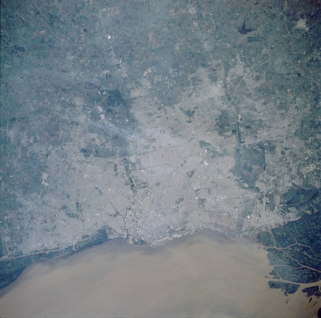 |
| STS056-103-099 Buenos Aires, Argentina April 1993 With a population of 12.2 million people, Buenos Aires has become the world's tenth largest metropolitan complex, with approximately 35 percent of the country's population residing in the greater Buenos Aires conurbation. Buenos Aires, the capital of Argentina, is also the country's chief seaport and its industrial, commercial, and social center. Situated on the southwestern end of the Rio de la Plata at the mouth of the Parana and Uruguay Rivers and the northeastern edge of the pampas (Argentina's most productive agricultural region), Buenos Aires has access to south-central South America and the rest of the world. The city has become the distribution hub and trading center for a large portion of southern South America. Several features of the urban infrastructure are visible in this near-vertical photograph--runways of airports, and highways and railroads radiating from the central part of the city, which is located near the waterfront. South of downtown, the Matanza River flows northeastward, emptying into the Rio de la Plata. |
| Images: | All Available Images Low-Resolution 113k |
|
| Mission: | STS056 |
|
| Roll - Frame: | 103 - 99 |
|
| Geographical Name: | ARGENTINA |
|
| Features: | BUENOS AIRES |
|
| Center Lat x Lon: | 34.5S x 58.5W |
|
| Film Exposure: | N | N=Normal exposure, U=Under exposed, O=Over exposed, F=out of Focus |
| Percentage of Cloud Cover-CLDP: | 0 |
|
| Camera:: | HB |
|
| Camera Tilt: | 2 | LO=Low Oblique, HO=High Oblique, NV=Near Vertical |
| Camera Focal Length: | 250 |
|
| Nadir to Photo Center Direction: | E | The direction from the nadir to the center point, N=North, S=South, E=East, W=West |
| Stereo?: | Y | Y=Yes there is an adjacent picture of the same area, N=No there isn't |
| Orbit Number: | 39 |
|
| Date: | 19930410 | YYYYMMDD |
| Time: | 153555 | GMT HHMMSS |
| Nadir Lat: | 34.5S |
Latitude of suborbital point of spacecraft |
| Nadir Lon: | 58.6W |
Longitude of suborbital point of spacecraft |
| Sun Azimuth: | 7 | Clockwise angle in degrees from north to the sun measured at the nadir point |
| Space Craft Altitude: | 164 | nautical miles |
| Sun Elevation: | 47 | Angle in degrees between the horizon and the sun, measured at the nadir point |
| Land Views: | PLAIN, COAST |
|
| Water Views: | SEDIMENT, ESTUARY, RIVER |
|
| Atmosphere Views: | |
|
| Man Made Views: | URBAN AREA, AIRPORT, AGRICULTURE |
|
| City Views: | BUENOS AIRES |
|
Photo is not associated with any sequences | ||
| NASA Home Page |
JSC Home Page |
JSC Digital Image Collection |
Earth Science & Remote Sensing |
|
This service is provided by the International Space Station program and the JSC Earth Science & Remote Sensing Unit, ARES Division, Exploration Integration Science Directorate.

|