
Geographic Region: ARGENTINA
Feature: RIO PARANA GUAZA
|
Geographic Region: ARGENTINA Feature: RIO PARANA GUAZA |
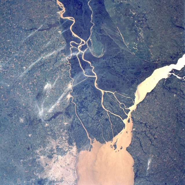 |
| STS056-102-004 Paraná River Delta, Argentina April 1993 The meandering sediment-laden stream channels of the lower Paraná River are easily distinguished from the darker, densely vegetated delta immediately north of Buenos Aires, Argentina. A thin, north-south-oriented line (perhaps a road, railroad, or both) is visible in this extensive delta that measures approximately 70 miles (110 kilometers) at its maximum width. The muddy, much broader Uruguay River, which forms part of the Argentina-Uruguay border, flows from the north past part of the delta. The Paraná River floodplain can be identified by the darker areas adjacent to its meandering river channels. Cultivated field patterns are observed on either side of the Paraná delta. Part of Buenos Aires, with a population of more than 12 million, is visible along the southern edge of the photograph. (Refer to STS-056-075-104 for a synoptic photograph of the Paraná River near Rosario, Argentina, and STS-056-103-099 for a closeup view of Buenos Aires.) |
| Images: | All Available Images Low-Resolution 171k |
|
| Mission: | STS056 |
|
| Roll - Frame: | 102 - 4 |
|
| Geographical Name: | ARGENTINA |
|
| Features: | RIO PARANA GUAZA |
|
| Center Lat x Lon: | 34S x 58.5W |
|
| Film Exposure: | N | N=Normal exposure, U=Under exposed, O=Over exposed, F=out of Focus |
| Percentage of Cloud Cover-CLDP: | 5 |
|
| Camera:: | HB |
|
| Camera Tilt: | 12 | LO=Low Oblique, HO=High Oblique, NV=Near Vertical |
| Camera Focal Length: | 100 |
|
| Nadir to Photo Center Direction: | N | The direction from the nadir to the center point, N=North, S=South, E=East, W=West |
| Stereo?: | Y | Y=Yes there is an adjacent picture of the same area, N=No there isn't |
| Orbit Number: | 39 |
|
| Date: | 19930410 | YYYYMMDD |
| Time: | 153601 | GMT HHMMSS |
| Nadir Lat: | 34.6S |
Latitude of suborbital point of spacecraft |
| Nadir Lon: | 58.5W |
Longitude of suborbital point of spacecraft |
| Sun Azimuth: | 7 | Clockwise angle in degrees from north to the sun measured at the nadir point |
| Space Craft Altitude: | 164 | nautical miles |
| Sun Elevation: | 47 | Angle in degrees between the horizon and the sun, measured at the nadir point |
| Land Views: | PLAIN, HILL, FOREST |
|
| Water Views: | RIVER, DELTA, RESERVOIR, SEDIMENT |
|
| Atmosphere Views: | |
|
| Man Made Views: | AGRICULTURE, URBAN AREA, DAM |
|
| City Views: | |
|
Photo is not associated with any sequences | ||
| NASA Home Page |
JSC Home Page |
JSC Digital Image Collection |
Earth Science & Remote Sensing |
|
This service is provided by the International Space Station program and the JSC Earth Science & Remote Sensing Unit, ARES Division, Exploration Integration Science Directorate.

|