Geographic Region: NEW ZEALAND-SI
Feature: LAKE TEKAPO, LAKE PUKAKI
|
Geographic Region: NEW ZEALAND-SI Feature: LAKE TEKAPO, LAKE PUKAKI |
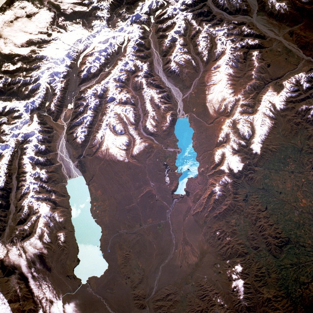 |
| STS056-101-064 Lake Pukaki and Lake Tekapo, South Island, New Zealand April 1993 This spectacular, north-northeast-looking, low-oblique photograph shows the high country of the Southern Alps and two glacier-fed lakes, Pukaki and Tekapo. Visible near the northwest corner of the photograph is Mount Cook, the highest peak in the Southern Alps at 12 349 feet (3766 meters). East of Mount Cook is the largest glacier in New Zealand, the Tasman Glacier, 18 miles (29 kilometers) long and more than 1 mile (2 kilometers) wide. The Southern Alps, paralleling the west coast of South Island, are extensively glaciated with many deep gorges. Of the 3155 active glaciers in the Southern Alps, most are within 100 miles (160 kilometers) of Mount Cook. From Tasman Glacier, the braided Tasman River can be seen flowing southward into beautiful Lake Pukaki. The lake is more than 9 miles (15 kilometers) long and covers 32 square miles (83 square kilometers). Its brilliant turquoise color results from finely ground "rock flour" being suspended in the water. East of the Tasman River, the braided Godley River flows into Lake Tekapo, a beautiful lake occupying a vast hollow in downs and terraces of golden tussock grass. Though a hydroelectric control structure now contains the waters of the lake at its southern end, Lake Tekapo owes its origin to the natural dam of an old moraine. East of Lake Tekapo, the agricultural lands of the fertile Canterbury Plain spread toward the coast. |
| Images: | All Available Images Low-Resolution 182k |
|
| Mission: | STS056 |
|
| Roll - Frame: | 101 - 64 |
|
| Geographical Name: | NEW ZEALAND-SI |
|
| Features: | LAKE TEKAPO, LAKE PUKAKI |
|
| Center Lat x Lon: | 44S x 170.5E |
|
| Film Exposure: | N | N=Normal exposure, U=Under exposed, O=Over exposed, F=out of Focus |
| Percentage of Cloud Cover-CLDP: | 5 |
|
| Camera:: | HB |
|
| Camera Tilt: | 32 | LO=Low Oblique, HO=High Oblique, NV=Near Vertical |
| Camera Focal Length: | 250 |
|
| Nadir to Photo Center Direction: | N | The direction from the nadir to the center point, N=North, S=South, E=East, W=West |
| Stereo?: | N | Y=Yes there is an adjacent picture of the same area, N=No there isn't |
| Orbit Number: | 61 |
|
| Date: | 19930412 | YYYYMMDD |
| Time: | 004912 | GMT HHMMSS |
| Nadir Lat: | 45.7S |
Latitude of suborbital point of spacecraft |
| Nadir Lon: | 170.2E |
Longitude of suborbital point of spacecraft |
| Sun Azimuth: | 357 | Clockwise angle in degrees from north to the sun measured at the nadir point |
| Space Craft Altitude: | 168 | nautical miles |
| Sun Elevation: | 36 | Angle in degrees between the horizon and the sun, measured at the nadir point |
| Land Views: | MOUNTAIN, GLACIER |
|
| Water Views: | RIVER, LAKE |
|
| Atmosphere Views: | |
|
| Man Made Views: | |
|
| City Views: | |
|
Photo is not associated with any sequences | ||
| NASA Home Page |
JSC Home Page |
JSC Digital Image Collection |
Earth Science & Remote Sensing |
|
This service is provided by the International Space Station program and the JSC Earth Science & Remote Sensing Unit, ARES Division, Exploration Integration Science Directorate.

|