Geographic Region: TANZANIA
Feature: LAKE EYASI, VERY SHALLOW
|
Geographic Region: TANZANIA Feature: LAKE EYASI, VERY SHALLOW |
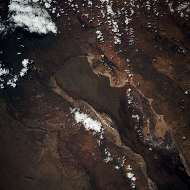 |
| STS055-093-038 Lake Eyasi, Tanzania May 1993 Lake Eyasi, located south of the Serengeti National Park and immediately southwest of the Ngorongoro Crater, is one of several lakes on the floor of the East African Rift Valley. The southwest flank of Ngorongoro Volcano drains into the northeast end of the lake. Although the southwestern quarter of the lake is not included in this photograph, the lake is generally rectangular, except the indented southeast side, which appears to be shallower because sediment has filled in the shore. Most of the former shoreline can be identified by the color change around the fairly steep embanked perimeter of the lake. Seasonal water level fluctuations in the lake are dramatic, perhaps indicating that Lake Eyasi is relatively shallow even during periods of maximum water levels. This photograph shows some dark water in the northeast part of the lake; however, recent Space Shuttle photographs have shown Eyasi to be almost devoid of water. |
| Images: | Images: | NO IMAGES YET | |||
| Mission: | STS055 |
||||
| Roll - Frame: | 93 - 38 |
||||
| Geographical Name: | TANZANIA |
||||
| Features: | LAKE EYASI, VERY SHALLOW |
||||
| Center Lat x Lon: | 3.5S x 35.0E |
||||
| Film Exposure: | N | N=Normal exposure, U=Under exposed, O=Over exposed, F=out of Focus |
|||
| Percentage of Cloud Cover-CLDP: | 15 |
||||
| Camera:: | HB |
||||
| Camera Tilt: | 19 | LO=Low Oblique, HO=High Oblique, NV=Near Vertical |
|||
| Camera Focal Length: | 250 |
||||
| Nadir to Photo Center Direction: | SE | The direction from the nadir to the center point, N=North, S=South, E=East, W=West |
|||
| Stereo?: | Y | Y=Yes there is an adjacent picture of the same area, N=No there isn't |
|||
| Orbit Number: | 109 |
||||
| Date: | 19930503 | YYYYMMDD |
|||
| Time: | 095140 | GMT HHMMSS |
|||
| Nadir Lat: | 2.9S |
Latitude of suborbital point of spacecraft | |||
| Nadir Lon: | 34.3E |
Longitude of suborbital point of spacecraft | |||
| Sun Azimuth: | 351 | Clockwise angle in degrees from north to the sun measured at the nadir point |
|||
| Space Craft Altitude: | 162 | nautical miles |
|||
| Sun Elevation: | 71 | Angle in degrees between the horizon and the sun, measured at the nadir point |
|||
| Land Views: | VALLEY, BASIN, ESCARPMENT, PLATEAU, FAULT |
||||
| Water Views: | LAKE, SEDIMENT, RIVER |
||||
| Atmosphere Views: | |
||||
| Man Made Views: | |
||||
| City Views: | |
||||
Photo is not associated with any sequences | |||||
| NASA Home Page |
JSC Home Page |
JSC Digital Image Collection |
Earth Science & Remote Sensing |
|
This service is provided by the International Space Station program and the JSC Earth Science & Remote Sensing Unit, ARES Division, Exploration Integration Science Directorate.

|