
Geographic Region:
Feature: LIGHT EARTHOBS
|
Geographic Region: Feature: LIGHT EARTHOBS |
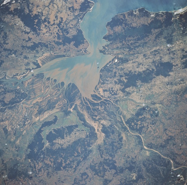 |
| STS055-086-071 Mahajamba Bay, Madagascar May 1993 The theme of this photograph--soil erosion--is depicted with two colors--dark green, the remaining vegetated areas (primarily grasslands), and various shades of brown, sediments transported into the Bay of Mahajamba. The bay, named for the Mahajamba River that flows into its southern part, is also entered by the Sofia River from the east. The mouth of Mahajamba Bay is not visible in this photograph; however, the heavy sediment loads carried through the estuary sometimes create sizable sediment plumes in the Mozambique Channel. This region along the northwest coast of Madagascar, the world's fourth largest island, indicates the country's major problem--overpopulation and destruction of forests. At the beginning of the 20th century the island had an estimated 90 percent vegetative cover, mostly forests; now approximately 100 years later, only 10 percent of the forests remain. With 80 percent of the population engaged in farming and the island's population doubling in 30 years (population increased from 5.4 to 11.2 million from 1960 to 1989), the stress on the land has been tremendous. The area shown in this picture is largely savanna--short grass with scattered trees. Chief agricultural activities are growing sugarcane and raising cattle. Annual rainfall amounts range from 40 to 80 inches (100 to 200 centimeters). |
| Images: | All Available Images Low-Resolution 153k |
|
| Mission: | STS055 |
|
| Roll - Frame: | 86 - 71 |
|
| Geographical Name: | |
|
| Features: | LIGHT EARTHOBS |
|
| Center Lat x Lon: | N x E |
|
| Film Exposure: | O | N=Normal exposure, U=Under exposed, O=Over exposed, F=out of Focus |
| Percentage of Cloud Cover-CLDP: | ||
| Camera:: | HB |
|
| Camera Tilt: | LO=Low Oblique, HO=High Oblique, NV=Near Vertical |
|
| Camera Focal Length: | |
|
| Nadir to Photo Center Direction: | The direction from the nadir to the center point, N=North, S=South, E=East, W=West |
|
| Stereo?: | Y=Yes there is an adjacent picture of the same area, N=No there isn't |
|
| Orbit Number: | |
|
| Date: | 19930501 | YYYYMMDD |
| Time: | 220250 | GMT HHMMSS |
| Nadir Lat: | 27.7S |
Latitude of suborbital point of spacecraft |
| Nadir Lon: | 67W |
Longitude of suborbital point of spacecraft |
| Sun Azimuth: | 286 | Clockwise angle in degrees from north to the sun measured at the nadir point |
| Space Craft Altitude: | 158 | nautical miles |
| Sun Elevation: | -2 | Angle in degrees between the horizon and the sun, measured at the nadir point |
| Land Views: | PLAIN, HILL |
|
| Water Views: | BAY, RIVER, SEDIMENT |
|
| Atmosphere Views: | |
|
| Man Made Views: | DEFORESTATION |
|
| City Views: | |
|
Photo is not associated with any sequences | ||
| NASA Home Page |
JSC Home Page |
JSC Digital Image Collection |
Earth Science & Remote Sensing |
|
This service is provided by the International Space Station program and the JSC Earth Science & Remote Sensing Unit, ARES Division, Exploration Integration Science Directorate.

|