Geographic Region: SUDAN
Feature: SUDD SWAMP, WHITE NILE
|
Geographic Region: SUDAN Feature: SUDD SWAMP, WHITE NILE |
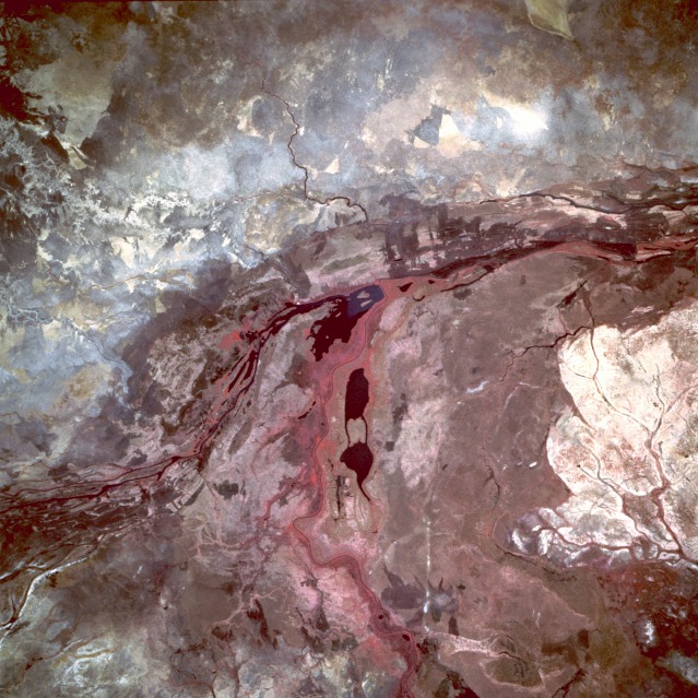 |
| STS055-085-003 Sudd Swamp and White Nile River, Southern Sudan May 1993 The color infrared properties of the film vividly portray much of the subtle detail of the northernmost area of the Sudd Swamp, the extensive floodplain that reaches for 340 miles (540 kilometers) from the Uganda border to the city of Malakal in southern Sudan. The Sudd is composed of multiple channels, lakes, and swampland, with a maze of thick, emergent aquatic vegetation. The photograph shows the confluence of the Bahr el Jebel (White Nile River) and one of its main tributaries, the Bahr al Ghazal, which joins the White Nile 80 miles (130 kilometers) west of Malakal. The main channel of the White Nile, identified by the reddish swath (green vegetation) along both banks, runs generally north-south. The Bahr al Ghazal, with its multibraided channels, flows northeastward to merge with the main channel of the White Nile near Lake No. Darker (almost black) areas are pockets of open water or lakes. The sizable whitish area along the southeast margin of the photograph is believed to be grassland that has been overgrazed by cattle. This photograph was taken during the driest time of year--summer rains generally extend from July through September. (Refer to STS-51G-046-0001 for another view of the Sudd Swamp in southern Sudan.) |
| Images: | All Available Images Low-Resolution 154k |
|
| Mission: | STS055 |
|
| Roll - Frame: | 85 - 3 |
|
| Geographical Name: | SUDAN |
|
| Features: | SUDD SWAMP, WHITE NILE |
|
| Center Lat x Lon: | 8.0N x 30.5E |
|
| Film Exposure: | N | N=Normal exposure, U=Under exposed, O=Over exposed, F=out of Focus |
| Percentage of Cloud Cover-CLDP: | 0 |
|
| Camera:: | HB |
|
| Camera Tilt: | 23 | LO=Low Oblique, HO=High Oblique, NV=Near Vertical |
| Camera Focal Length: | 250 |
|
| Nadir to Photo Center Direction: | SE | The direction from the nadir to the center point, N=North, S=South, E=East, W=West |
| Stereo?: | N | Y=Yes there is an adjacent picture of the same area, N=No there isn't |
| Orbit Number: | 46 |
|
| Date: | 19930429 | YYYYMMDD |
| Time: | 105810 | GMT HHMMSS |
| Nadir Lat: | 8.7N |
Latitude of suborbital point of spacecraft |
| Nadir Lon: | 29.6E |
Longitude of suborbital point of spacecraft |
| Sun Azimuth: | 294 | Clockwise angle in degrees from north to the sun measured at the nadir point |
| Space Craft Altitude: | 161 | nautical miles |
| Sun Elevation: | 74 | Angle in degrees between the horizon and the sun, measured at the nadir point |
| Land Views: | PLAIN, HILL |
|
| Water Views: | RIVER, SWAMP, LAKE |
|
| Atmosphere Views: | |
|
| Man Made Views: | DEFORESTATION |
|
| City Views: | |
|
Photo is not associated with any sequences | ||
| NASA Home Page |
JSC Home Page |
JSC Digital Image Collection |
Earth Science & Remote Sensing |
|
This service is provided by the International Space Station program and the JSC Earth Science & Remote Sensing Unit, ARES Division, Exploration Integration Science Directorate.

|